
Home - Search - Browse - Alphabetic Index: 0- 1- 2- 3- 4- 5- 6- 7- 8- 9
A- B- C- D- E- F- G- H- I- J- K- L- M- N- O- P- Q- R- S- T- U- V- W- X- Y- Z
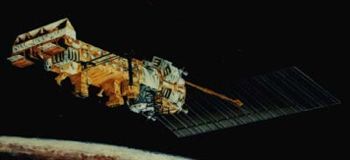
Tiros N
 Tiros-N Credit: NASA |
Status: Operational 1978. First Launch: 1978-10-13. Last Launch: 2002-06-24. Number: 6 . Gross mass: 1,416 kg (3,121 lb). Height: 3.70 m (12.10 ft).
These satellites made measurements of atmospheric temperature and humidity, surface temperature, cloud cover, water-ice-moisture boundaries, and space proton and electron fluxes. They could receive, process, and retransmit data from free-floating balloons, buoys, and remote automatic stations around the globe.
These satellites were managed by NOAA (National Oceanic and Atmospheric Administration) and NASA was responsible for developing and launching the spacecraft. The NOAA spacecraft used a letter designator (NOAA G) before launch, and received a numeric designator after reaching orbit. TIROS-N through NOAA-D were called the TIROS-N series. NOAA-E through NOAA-N were called the TIROS ATN series (Advanced TIROS N). NOAA-D was launched out of sequence and later became NOAA 12.
The spacecraft were 3-axis stabilized, nadir pointing with control to 0.1 deg using reaction wheels. The TIROS-N series incorporated significant design heritage from DMSP. A hydrazine propulsion system was used for orbit maintenance. A single solar panel generated over 1 kW (EOL). NiCd batteries provided power during eclipse. The structure was an elongated 5-sided box constructed of aluminum and titanium. S-Band communications were used with NOAA/NESDIS ground stations located in Redwood City, CA; Wallops, VA; and Fairbanks, AK.
Payloads included:
UL>
More at: Tiros N.
| TIROS-N, NOAA 6, B, 7 Meteorology satellite built by RCA Astro for NOAA, USA. Launched 1978 - 1994. Used the TIROS-N Bus bus. |
| DMSP Block 5D-2 American earth weather satellite. DMSP 5D-2 was the military's sixth generation of weather satellites. Meteorology satellite built by RCA Astro → GE Astro → Martin Marietta → Lockheed Martin Astro, USA. Launched 1982 - 1997. Used the TIROS-N Bus bus. |
| NOAA 8, 9, 10, 11, 12, 13, 14 (NOAA E, F, G, H, D, I, J) Null |
| NOAA 15, 16, 17 (NOAA K, L, M) Null |
| Landsat 7 American earth land resources satellite. Earth Observing satellite built by Lockheed Martin for NASA, USA. Launched 1993 - 1999. Used the TIROS-N Bus bus. |
| DMSP Block 5D-3 American earth weather satellite.merican earth weather satellite. Military spacecraft similar in design to the civilian NOAA weather satellites. Meteorology satellite built by Lockheed Martin for US Air Force, USA. Launched 1999 - 2014. Used the TIROS-N Bus bus. |
| NOAA 18, 19 (NOAA N, N') Null |
| N-ROSS Earth observation, oceanography satellite built by GE Astro-Space or Lockheed for US Navy. Used the TIROS-N Bus bus. |
Family: Earth, Earth weathersat, Sun synchronous orbit. Country: USA. Spacecraft: TIROS. Launch Vehicles: Titan, Atlas, Titan II, Atlas E, Atlas F, Titan II SLV. Launch Sites: Vandenberg, Vandenberg SLC3W, Vandenberg SLC4W. Agency: NASA, NOAA, Martin, RCA, Astro Space. Bibliography: 2, 278, 279, 3977, 3978, 3979, 3980, 552, 554, 6, 13279, 13280.
 | NOAA 8 Credit: Manufacturer Image |
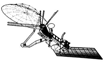 | N-ROSS Credit: Manufacturer Image |
1978 October 13 - . 11:23 GMT - . Launch Site: Vandenberg. Launch Complex: Vandenberg SLC3W. LV Family: Atlas. Launch Vehicle: Atlas F.
- Tiros N - .
Mass: 734 kg (1,618 lb). Nation: USA.
Agency: NASA Greenbelt.
Program: Tiros.
Class: Earth.
Type: Weather satellite. Spacecraft: Tiros N.
USAF Sat Cat: 11060 . COSPAR: 1978-096A. Apogee: 845 km (525 mi). Perigee: 829 km (515 mi). Inclination: 98.70 deg. Period: 101.70 min.
An Atlas booster launched a TIROS-N prototype weather satellite designed and funded by NASA for the National Oceanic and Atmospheric Administration. The launch took place at Vandenberg AFB and was successful. Spacecraft engaged in practical applications and uses of space technology such as weather or communication (US Cat C).
1979 June 27 - . 15:51 GMT - . Launch Site: Vandenberg. Launch Complex: Vandenberg SLC3W. LV Family: Atlas. Launch Vehicle: Atlas F.
- NOAA 6 - . Payload: NOAA A. Mass: 723 kg (1,593 lb). Nation: USA. Agency: NOAA. Program: Tiros. Class: Earth. Type: Weather satellite. Spacecraft: Tiros N. USAF Sat Cat: 11416 . COSPAR: 1979-057A. Apogee: 800 km (490 mi). Perigee: 785 km (487 mi). Inclination: 98.60 deg. Period: 100.70 min. Atlas booster 25F successfully launched NASA's NOAA-A satellite from Vandenberg AFB, California. Spacecraft engaged in practical applications and uses of space technology such as weather or communication (US Cat C)..
1980 May 29 - . 10:53 GMT - . Launch Site: Vandenberg. Launch Complex: Vandenberg SLC3W. LV Family: Atlas. Launch Vehicle: Atlas F. FAILURE: Atlas sustainer engine under-thrust resulted in 50 second extended burn time, and spacecraft attempted to separate and fired apogee kick motor while booster was still thrusting.. Failed Stage: P.
- NOAA B - .
Payload: NOAA B. Mass: 1,405 kg (3,097 lb). Nation: USA.
Agency: NOAA.
Program: Tiros.
Class: Earth.
Type: Weather satellite. Spacecraft: Tiros N.
Decay Date: 1981-05-03 . USAF Sat Cat: 11819 . COSPAR: 1980-043A. Apogee: 1,445 km (897 mi). Perigee: 264 km (164 mi). Inclination: 92.20 deg. Period: 102.10 min.
Unusable orbit; would have been NOAA 7. At engine start up, one of the booster engines suffered an internal fuel leak, causing it to run at about 80% thrust. As a result the booster was low on velocity and heavy on propellant over much of its flight and ran an incredible 50 seconds longer than the nominal burn. The NOAA Advanced TIROS payload was designed with no direct communication with the booster, and unaware of the booster problem, at 375 sec after liftoff attempted to separate with the booster still firing. The booster's continued thrusting defeated the payload's attempt to perform the required pitch maneuver. When the payload fired its apogee kick motor, it blew the top of the booster's liquid oxygen tank off. The spacecraft survived all this, but the resultant orbit was highly elliptical rather than the desired circular sun-synchronous. The mission was a total loss. Officially: Spacecraft engaged in practical applications and uses of space technology such as weather or communication (US Cat C).>
1981 June 23 - . 10:52 GMT - . Launch Site: Vandenberg. Launch Complex: Vandenberg SLC3W. LV Family: Atlas. Launch Vehicle: Atlas F.
- NOAA 7 - . Payload: NOAA C. Mass: 1,405 kg (3,097 lb). Nation: USA. Agency: NOAA. Program: Tiros. Class: Earth. Type: Weather satellite. Spacecraft: Tiros N. USAF Sat Cat: 12553 . COSPAR: 1981-059A. Apogee: 847 km (526 mi). Perigee: 828 km (514 mi). Inclination: 98.90 deg. Period: 101.70 min. Spacecraft engaged in practical applications and uses of space technology such as weather or communication (US Cat C)..
1982 December 21 - . 02:38 GMT - . Launch Site: Vandenberg. Launch Complex: Vandenberg SLC3W. LV Family: Atlas. Launch Vehicle: Atlas E.
- AMS 5 - . Payload: DMSP S-6 / OPS 9845. Mass: 750 kg (1,650 lb). Nation: USA. Agency: USAF. Program: DMSP. Class: Earth. Type: Weather satellite. Spacecraft Bus: TIROS N. Spacecraft: DMSP Block 5D-2. USAF Sat Cat: 13736 . COSPAR: 1982-118A. Apogee: 810 km (500 mi). Perigee: 797 km (495 mi). Inclination: 98.60 deg. Period: 100.90 min. Defense Meteorological Satellite Program..
1983 November 18 - . 06:32 GMT - . Launch Site: Vandenberg. Launch Complex: Vandenberg SLC3W. LV Family: Atlas. Launch Vehicle: Atlas E.
- DMSP-Block-5B5D2-2 - . Payload: DMSP S-7 / OPS 1294. Mass: 750 kg (1,650 lb). Nation: USA. Agency: USAF. Program: DMSP. Class: Earth. Type: Weather satellite. Spacecraft Bus: TIROS N. Spacecraft: DMSP Block 5D-2. USAF Sat Cat: 14506 . COSPAR: 1983-113A. Apogee: 818 km (508 mi). Perigee: 801 km (497 mi). Inclination: 98.40 deg. Period: 101.10 min. Defense Meteorological Satellite Program..
1987 June 20 - . 02:34 GMT - . Launch Site: Vandenberg. Launch Complex: Vandenberg SLC3W. LV Family: Atlas. Launch Vehicle: Atlas E.
- USA 26 - . Payload: DMSP S-9/Star 37S S/N 15019. Mass: 750 kg (1,650 lb). Nation: USA. Agency: USAF. Program: DMSP. Class: Earth. Type: Weather satellite. Spacecraft Bus: TIROS N. Spacecraft: DMSP Block 5D-2. USAF Sat Cat: 18123 . COSPAR: 1987-053A. Apogee: 848 km (526 mi). Perigee: 828 km (514 mi). Inclination: 98.80 deg. Period: 101.70 min. Defense Meteorological Satellite Program..
1988 February 3 - . 05:53 GMT - . Launch Site: Vandenberg. Launch Complex: Vandenberg SLC3W. LV Family: Atlas. Launch Vehicle: Atlas E.
- USA 29 - . Payload: DMSP S-8/Star 37S S/N 15021. Mass: 750 kg (1,650 lb). Nation: USA. Agency: USAF. Program: DMSP. Class: Earth. Type: Weather satellite. Spacecraft Bus: TIROS N. Spacecraft: DMSP Block 5D-2. USAF Sat Cat: 18822 . COSPAR: 1988-006A. Apogee: 817 km (507 mi). Perigee: 807 km (501 mi). Inclination: 98.50 deg. Period: 101.10 min. Defense Meteorological Satellite Program..
1990 December 1 - . 15:57 GMT - . Launch Site: Vandenberg. Launch Complex: Vandenberg SLC3W. LV Family: Atlas. Launch Vehicle: Atlas E. FAILURE: Failure of the spacecraft's TEM-364-15 AKM nozzle due to a manufacturing defect led to the satellite being placed into lower than planned orbit.. Failed Stage: P.
- USA 68 - . Payload: DMSP S-10. Mass: 750 kg (1,650 lb). Nation: USA. Agency: USAF. Program: DMSP. Class: Earth. Type: Weather satellite. Spacecraft Bus: TIROS N. Spacecraft: DMSP Block 5D-2. USAF Sat Cat: 20978 . COSPAR: 1990-105A. Apogee: 837 km (520 mi). Perigee: 724 km (449 mi). Inclination: 98.70 deg. Period: 100.50 min. Defense Meteorological Satellite Program; broken nozzle prevented satellite from reaching desired orbit..
1991 May 14 - . 15:52 GMT - . Launch Site: Vandenberg. Launch Complex: Vandenberg SLC3W. LV Family: Atlas. Launch Vehicle: Atlas E.
- NOAA 12 - . Payload: NOAA D. Mass: 1,416 kg (3,121 lb). Nation: USA. Agency: NOAA. Program: Tiros. Class: Earth. Type: Weather satellite. Spacecraft: Tiros N. USAF Sat Cat: 21263 . COSPAR: 1991-032A. Apogee: 824 km (512 mi). Perigee: 805 km (500 mi). Inclination: 98.60 deg. Period: 101.20 min. Spacecraft engaged in research and exploration of the upper atmosphere or outer space (US Cat B). .
1991 November 28 - . 13:23 GMT - . Launch Site: Vandenberg. Launch Complex: Vandenberg SLC3W. LV Family: Atlas. Launch Vehicle: Atlas E.
- USA 73 - . Payload: DMSP S-12/Star 37S S/N 15029. Mass: 830 kg (1,820 lb). Nation: USA. Agency: USAF. Program: DMSP. Class: Earth. Type: Weather satellite. Spacecraft Bus: TIROS N. Spacecraft: DMSP Block 5D-2. USAF Sat Cat: 21798 . COSPAR: 1991-082A. Apogee: 852 km (529 mi). Perigee: 835 km (518 mi). Inclination: 99.00 deg. Period: 101.80 min. Defense Meteorological Satellite Program. 500th Atlas launch..
1994 August 29 - . 17:38 GMT - . Launch Site: Vandenberg. Launch Complex: Vandenberg SLC3W. LV Family: Atlas. Launch Vehicle: Atlas E.
- USA 106 - . Payload: DMSP 23545/Star 37S S/N 15030 / DMSP 5D-1 F12. Mass: 830 kg (1,820 lb). Nation: USA. Agency: USAF. Program: DMSP. Class: Earth. Type: Weather satellite. Spacecraft Bus: TIROS N. Spacecraft: DMSP Block 5D-2. USAF Sat Cat: 23233 . COSPAR: 1994-057A. Apogee: 860 km (530 mi). Perigee: 840 km (520 mi). Inclination: 98.89 deg. Period: 101.94 min. Defense Meteorological Satellite Program..
1995 March 24 - . 14:05 GMT - . Launch Site: Vandenberg. Launch Complex: Vandenberg SLC3W. LV Family: Atlas. Launch Vehicle: Atlas E.
- USA 109 - . Payload: DMSP 24547/Star 37S / DMSP F13. Mass: 750 kg (1,650 lb). Nation: USA. Agency: USAF. Program: DMSP. Class: Earth. Type: Weather satellite. Spacecraft Bus: TIROS N. Spacecraft: DMSP Block 5D-2. USAF Sat Cat: 23533 . COSPAR: 1995-015A. Apogee: 854 km (530 mi). Perigee: 845 km (525 mi). Inclination: 98.80 deg. Period: 101.90 min. Last successful Atlas E space launch..
1997 April 4 - . 16:47 GMT - . Launch Site: Vandenberg. Launch Complex: Vandenberg SLC4W. LV Family: Titan. Launch Vehicle: Titan II SLV.
- USA 131 - . Payload: DMSP 5D-2 F-14. Mass: 770 kg (1,690 lb). Nation: USA. Agency: USAF. Manufacturer: RCA. Program: DMSP. Class: Earth. Type: Weather satellite. Spacecraft Bus: TIROS N. Spacecraft: DMSP Block 5D-2. USAF Sat Cat: 24753 . COSPAR: 1997-012A. Apogee: 855 km (531 mi). Perigee: 842 km (523 mi). Inclination: 98.90 deg. Period: 101.90 min.
1999 April 15 - . 18:32 GMT - . Launch Site: Vandenberg. Launch Complex: Vandenberg SLC2W. LV Family: Thor. Launch Vehicle: Delta 7920-10.
- Landsat 7 - .
Mass: 1,969 kg (4,340 lb). Nation: USA.
Agency: NASA Greenbelt.
Manufacturer: Valley Forge.
Program: Landsat.
Class: Earth.
Type: Earth resources satellite. Spacecraft Bus: TIROS N.
Spacecraft: Landsat 7.
USAF Sat Cat: 25682 . COSPAR: 1999-020A. Apogee: 703 km (436 mi). Perigee: 702 km (436 mi). Inclination: 98.20 deg. Period: 98.80 min.
The vehicle entered a 175 km x 706 km x 98.2 deg initial orbit. 57 minutes after launch the Delta stage burned again to circularize the orbit at 668 km x 698 km and Landsat 7 separated from the stage. The Delta stage then burned to depletion of its propellant, into a 184 km x 710 km x 107.5 deg orbit that would decay quickly. The Landsat 7 remote sensing satellite was to be operated by NASA/Goddard until October 2000, when operations would be transferred to the US Geological Survey.
1999 December 12 - . 17:38 GMT - . Launch Site: Vandenberg. Launch Complex: Vandenberg SLC4W. LV Family: Titan. Launch Vehicle: Titan II SLV.
- USA 147 - . Payload: DMSP 5D-3 F-15. Mass: 1,154 kg (2,544 lb). Nation: USA. Agency: USAF. Manufacturer: RCA. Class: Earth. Type: Weather satellite. Spacecraft Bus: TIROS N. Spacecraft: DMSP Block 5D-3. USAF Sat Cat: 25991 . COSPAR: 1999-067A. Apogee: 846 km (525 mi). Perigee: 830 km (510 mi). Inclination: 98.50 deg. Period: 101.70 min. First launch of the Block 5D-3 military weather satellite. Satellite F-15 was placed in an initial suborbital trajectory. The Star 37S kick motor on the satellite fired 13 minutes after launch for orbit insertion..
2002 June 24 - . 18:23 GMT - . Launch Site: Vandenberg. Launch Complex: Vandenberg SLC4W. LV Family: Titan. Launch Vehicle: Titan II SLV.
- NOAA 17 - .
Payload: NOAA-M. Mass: 1,475 kg (3,251 lb). Nation: USA.
Agency: NOAA.
Manufacturer: Lockheed.
Program: Tiros.
Class: Earth.
Type: Weather satellite. Spacecraft: Tiros N.
USAF Sat Cat: 27453 . COSPAR: 2002-032A. Apogee: 820 km (500 mi). Perigee: 802 km (498 mi). Inclination: 98.40 deg. Period: 101.10 min.
Launch delayed from August 2001. The refurbished Titan 2 missile put the NOAA M satellite on a suborbital trajectory of about -2500 x 820 km x 98 deg. at 1829 UTC. At 1837 UTC the NOAA M propulsion module fired its ATK/Thiokol Star 37XFP solid motor for the orbit insertion burn, followed by a hydrazine trim burn to put the satellite in an 807 x 822 km x 98.8 deg operational orbit. NOAA M became NOAA 17 on entering service with the US National Oceanic and Atmospheric Administration as the primary morning weather satellite, supplementing the NOAA 16 afternoon satellite. Built by Lockheed Martin, NOAA M carried weather imagers and microwave and infrared sounders, as well as a SARSAT search-and-rescue package. It had an on-orbit mass of 1475 kg.
2003 October 18 - . 16:17 GMT - . Launch Site: Vandenberg. Launch Complex: Vandenberg SLC4W. LV Family: Titan. Launch Vehicle: Titan II SLV.
- USA 172 - . Payload: DMSP-16. Mass: 1,154 kg (2,544 lb). Nation: USA. Agency: USAF. Class: Earth. Type: Weather satellite. Spacecraft Bus: TIROS N. Spacecraft: DMSP Block 5D-3. USAF Sat Cat: 28054 . COSPAR: 2003-048A. Apogee: 853 km (530 mi). Perigee: 843 km (523 mi). Inclination: 98.90 deg. Period: 101.90 min. Final Titan 2 launch, LV dubbed "Cindy Marie". Originally to have launched January 2001. Launch postponed 12 times due to spacecraft and launch vehicle problems..
2006 November 4 - . 13:53 GMT - . Launch Site: Vandenberg. Launch Complex: Vandenberg SLC6. LV Family: Delta IV. Launch Vehicle: Delta 4M.
- DMSP-Block-5D3-F17 - .
Mass: 1,154 kg (2,544 lb). Nation: USA.
Agency: USAF.
Program: DMSP.
Class: Earth.
Type: Weather satellite. Spacecraft Bus: TIROS N.
Spacecraft: DMSP Block 5D-3.
USAF Sat Cat: 29522 . COSPAR: 2006-050A. Apogee: 855 km (531 mi). Perigee: 841 km (522 mi). Inclination: 98.80 deg. Period: 101.90 min.
Defense Meteorological Satellite Program satellite with the Operational Linescan System camera, a microwave imager-sounder, ultraviolet spectrometers, particle detectors, a magnetometer, and a laser threat warning sensor. Reportedly went for a time into safe mode due to software problems after launch. The booster upper stage was conducted a maneuver to deorbit itself after placing the satellite in orbit. After the burn an explosion evidently occurred aboard the stage - dozens of objects were tracked in various orbits with perigees down to 670 km and apogees up to 851 km.
2009 October 18 - . 16:12 GMT - . Launch Site: Vandenberg. Launch Complex: Vandenberg SLC3E. LV Family: Atlas V. Launch Vehicle: Atlas V 401.
- USA 210 - . Payload: DMSP 5D F-18. Mass: 1,200 kg (2,600 lb). Nation: USA. Agency: Martin. Class: Earth. Type: Weather satellite. Spacecraft Bus: TIROS N. Spacecraft: DMSP Block 5D-3. USAF Sat Cat: 35951 . COSPAR: 2009-057A. Apogee: 858 km (533 mi). Perigee: 843 km (523 mi). Inclination: 98.90 deg. Period: 101.90 min. Defense Meteorological Satellite Program. After release of the weather satellite the Centaur AV-017 upper stage was tested, having enough propellant left over to escape the earth's gravity and enter solar orbit..
2014 April 3 - . 14:46 GMT - . Launch Site: Vandenberg. Launch Complex: Vandenberg SLC3E. LV Family: Atlas V. Launch Vehicle: Atlas V 401.
- USA 249 - .
Payload: DMSP 5D-3 F19. Mass: 1,200 kg (2,600 lb). Nation: USA.
Class: Earth.
Type: Weather satellite. Spacecraft Bus: TIROS N.
Spacecraft: DMSP Block 5D-3.
USAF Sat Cat: 39630 . COSPAR: 2014-015A. Apogee: 853 km (530 mi). Perigee: 839 km (521 mi). Inclination: 98.77 deg. Period: 101.85 min.
Penultimate US Air Force Defense Meteorological Satellite Program payload in orbit. The DMSP Block 5D-3 S-19 spacecraft was built by RCA/East Windsor, New Jersey and transferred to Lockheed Martin/Sunnyvale after closure of the former facility. The AV-044 Centaur stage reignited to go into heliocentric orbit, like that for the previous DMSP launch. The DMSP satellite's solar array did not completely deploy, but the satellite was expected to enter service nonetheless.
Back to top of page
Home - Search - Browse - Alphabetic Index: 0- 1- 2- 3- 4- 5- 6- 7- 8- 9
A- B- C- D- E- F- G- H- I- J- K- L- M- N- O- P- Q- R- S- T- U- V- W- X- Y- Z
© 1997-2019 Mark Wade - Contact
© / Conditions for Use