
Home - Search - Browse - Alphabetic Index: 0- 1- 2- 3- 4- 5- 6- 7- 8- 9
A- B- C- D- E- F- G- H- I- J- K- L- M- N- O- P- Q- R- S- T- U- V- W- X- Y- Z
Calipso
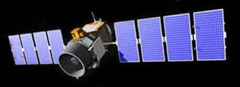 Calipso Credit: Manufacturer Image |
Status: Operational 2006. First Launch: 2006-04-28. Last Launch: 2006-04-28. Number: 1 . Gross mass: 587 kg (1,294 lb).
The Calipso Cloud-Aerosol Lidar and Infrared Pathfinder Satellite Observations satellite 's mission was to carry out high-resolution observations of aerosols in the earth's atmosphere using a 1-meter laser lidar telescope and an imaging infrared radiometer.
Calipso was co-manifested with CloudSat satellite for launch aboard a Delta II rocket. CloudSat and Calipso joined three satellites already in orbit ( Aqua, Parasol, and Aura) to form a constellation of satellites known as the A-Train. The satellites flew in a nearly circular orbit with an equatorial altitude of approximately 705 km. The orbit was sun-synchronous, maintaining a roughly fixed angle between the orbital plane and the mean solar meridian. Calipso maintained a close formation with Aqua and a particularly close formation with CloudSat, providing near-simultaneous and collocated observations with the instruments on these two platforms.
The following lists the measurements needed to address the Calipso science objectives and indicates a number of the synergies available from combining Calipso observations with the additional measurements available from the other instruments of the constellation.
- Science Objective Measurement: Calipso Constellation
- Direct aerosol forcing Aerosol vertical distribution and extinction profiles: CALIOP
- Aerosol optical depth: CALIOP Aqua-MODIS, PARASOL
- Aerosol type information: CALIOP Aqua-MODIS, PARASOL
- Aerosol absorption: Aura-OMI
- Broadband radiances: Aqua-CERES
- Indirect aerosol forcing Aerosol and cloud vertical distributions: CALIOP
- Cloud reflectance and droplet size: Aqua-MODIS
- Broadband radiances: Aqua-CERES
- Long wave surface and atmospheric fluxes: Cloud height and thickness, multilayering: CALIOP (thin cloud) CloudSat-CPR (thick cloud)
- Cloud ice/water phase: CALIOP (profiles) PARASOL, Aqua-MODIS (cloud-top only)
- Cirrus emissivity and particle size: CALIOP + IIR + WFC Aqua-MODIS, AIRS
- Other cloud properties: CloudSat, PARASOL, Aqua-MODIS, AIRS, AMSR/E
- Broadband radiances: Aqua-CERES
- Cloud radiative feedbacks: All elements of long wave surface and atmospheric fluxes plus: Cloud optical depth CALIOP Aqua-MODIS, PARASOL
- Cloud-Aerosol Lidar with Orthogonal Polarization (CALIOP): CALIOP was a two-wavelength polarization-sensitive lidar that provides high-resolution vertical profiles of aerosols and clouds. CALIOP utilized three receiver channels: one measuring the 1064 nm backscatter intensity and two channels measuring orthogonally polarized components of the 532 nm backscattered signal. Dual 14-bit digitizers on each channel provided an effective 22-bit dynamic range. The receiver telescope was 1 meter in diameter. A redundant laser transmitter was included in the payload. An active boresight system was employed to maintain co-alignment between the transmitter and the receiver. Ball Aerospace Corporation developed the instrument. Characteristics:
- laser: Nd: YAG, diode-pumped, Q-switched, frequency doubled
- wavelengths: 532 nm, 1064 nm
- pulse energy: 110 mJoule/channel
- repetition rate: 20.25 Hz
- receiver telescope: 1.0 m diameter
- polarization: 532 nm
- footprint/FOV: 100 m/ 130 µrad
- vertical resolution: 30-60 m
- horizontal resolution: 333 m
- linear dynamic range: 22 bits
- data rate: 316 kbps
- Wide Field Camera (WFC): The WFC was a modified version of the commercial off-the-shelf Ball Aerospace CT-633 star tracker camera. It was a fixed, nadir-viewing imager with a single spectral channel covering the 620-270 nm region, selected to match band 1 of the MODIS (MODerate resolution Imaging Spectroradiometer) instrument on Aqua. Characteristics: wavelength: 645 nm; spectral bandwidth: 50 nm; IFOV/swath: 125 m/61 km; data rate: 26 kbps.
- Imaging Infrared Radiometer (IIR): A three-channel IIR was provided by CNES with algorithm development performed by the Institute Pierre Simon Laplace (IPSL) in Paris. The IIR nadir-viewing, non-scanning imager had a 64 km by 64 km swath with a pixel size of 1 km. The CALIOP beam was nominally aligned with the center of the IIR image. The instrument used a single microbolometer detecter array, with a rotating filter wheel providing measurements at three channels in the thermal infrared window region at 8.7 mm, 10.5 mm, and 12.0 mm. These wavelengths were selected to optimize joint CALIOP/IIR retrievals of cirrus cloud emissivity and particle size. Characteristics: wavelengths: 8.65 µm, 10.6 µm, 12.0 µm; spectral resolution: 0.6 µm - 1.0 µm; IFOV/swath: 1 km/64 km; NETD at 210K: 0.3K; calibration: +/- 1K; data rate: 44 kbps.
More at: Calipso.
Family: Earth, Earth weathersat, Sun synchronous orbit. Country: USA. Launch Vehicles: Thor, Delta, Delta 7420-10C. Launch Sites: Vandenberg, Vandenberg SLC2W. Agency: NASA, Alenia. Bibliography: 2, 6400, 12162.
2006 April 28 - . 10:02 GMT - . Launch Site: Vandenberg. Launch Complex: Vandenberg SLC2W. LV Family: Thor. Launch Vehicle: Delta 7420-10C.
- Calipso - . Mass: 587 kg (1,294 lb). Nation: USA. Agency: CNES, NASA. Manufacturer: Alenia. Class: Earth. Type: Weather satellite. Spacecraft Bus: Proteus. Spacecraft: Calipso. USAF Sat Cat: 29108 . COSPAR: 2006-016B. Apogee: 703 km (436 mi). Perigee: 702 km (436 mi). Inclination: 98.20 deg. Period: 98.80 min. Calipso carried a 1-meter laser lidar telescope to study clouds and aerosols, and an imaging infrared radiometer..
Back to top of page
Home - Search - Browse - Alphabetic Index: 0- 1- 2- 3- 4- 5- 6- 7- 8- 9
A- B- C- D- E- F- G- H- I- J- K- L- M- N- O- P- Q- R- S- T- U- V- W- X- Y- Z
© 1997-2019 Mark Wade - Contact
© / Conditions for Use