Home - Search - Browse - Alphabetic Index: 0- 1- 2- 3- 4- 5- 6- 7- 8- 9
A- B- C- D- E- F- G- H- I- J- K- L- M- N- O- P- Q- R- S- T- U- V- W- X- Y- Z
Almaz-T
AKA: 11F668;Almaz-K;Mech-K. Status: Operational 1986. First Launch: 1986-11-29. Last Launch: 1991-03-31. Number: 3 . Thrust: 7.84 kN (1,763 lbf). Gross mass: 18,500 kg (40,700 lb). Specific impulse: 291 s.
There was minimal time to operate the equipment after the crew took the necessary time for maintenance of station housekeeping and environmental control systems.
The experiments themselves showed good results and especially the value of reconnaissance of the same location in many different spectral bands and parts of the electromagnetic spectrum. Therefore the program was not cancelled, but to be followed by the Almaz-T system, which was to be a multi-satellite multi-spectral system for sustained reconnaissance.
As a counterpoint to the American Lacrosse satellite, this version of Almaz had an enormous S-Band synthetic aperture radar which returned images of 10 to 15 meter resolution. The first such Almaz-T was to be launched in 1981. However, an order arrived from Moscow ten days prior to the launch - terminate the Almaz Program as a result of work on Buran. Ustinov had decided to deal the finishing blow to Chelomei. All work on Almaz was suspended by a decree of the Central Committee issued on 19 December 1981.
Only after the deaths of Chelomei and Ustinov (they died the same year two weeks apart) did new Chief Designer Gerbert Yefremov manage to convince Minister of Defense Sokolov that the program needed to be continued. They authorized him to prepare for launch the station that had collected dust for six years at the Baikonur test range.
The VPK Military-Industrial Commission's resolution 126 of 12 April 1986 revived the Almaz program. To the designers' surprise, the Almaz was in decent condition (in contrast to its fairing, which had been used as a toilet). It had only been saved by its external placards - 'Warning - Don't Enter - Self-Destruct Charges on Board'. This much-suffering Almaz was launched on November 29, 1986. But the second stage did not separate for the first time in many years and the same self-destruct charges destroyed the Almaz.
The next Almaz-T was erected on the launch pad on June 25, 1987. The Proton launch vehicle normally cannot be kept fueled, on hold, for more than four days. An order once again arrived at Baikonur - delay the launch and remove the rocket from the launch pad. The order was ignored, with extraordinary measures being taken to keep the station inside the shroud at normal temperatures despite hot summer days of 42 degrees C. Minister of General Machine Building Baklanov was at Baikonur, and he finally agreed to allow launch of the spacecraft. It received the name Cosmos 1870 and provided radar imagery to scientific and commercial customers for two years. The satellite had a sideward-looking radar with a ground resolution of 20 to 25 m, coupled to a high-resolution television system. The satellite functioned from 25 July 1987 to 30 July 1989.
A second Almaz-T was flown in 1991 as Almaz-1. The satellite had an improved radar resolution of 10-12 m, with data streamed directly to users via transponder satellites. This spacecraft was instrumental in the rescue of an expedition lost on the ice of Antarctica aboard the ship Mikhail Somov. No other sensor could locate the ship in the perpetual polar night.
In 1992, the Machine Building NPO began to develop a new Almaz-T, with three radars and an optical telescope. But financing was not forthcoming.
Habitable Volume: 90.00 m3.
More at: Almaz-T.
Family: Civilian radarsat, Surveillance, Surveillance orbit. Country: Russia. Engines: RD-0225. Launch Vehicles: Proton, Proton-K. Propellants: N2O4/UDMH. Launch Sites: Baikonur, Baikonur LC200/40. Agency: MOM, Reshetnev bureau. Bibliography: 102, 2, 274, 385, 443, 445, 6, 67, 12039.
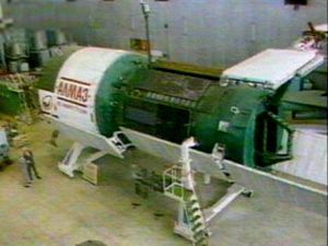
 | Almaz-T s/n 303 Fail Credit: Manufacturer Image |
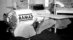
 | Almaz 1 Credit: Manufacturer Image |
 | Almaz-T |
1986 November 29 - . 08:00 GMT - . Launch Site: Baikonur. Launch Complex: Baikonur LC200/40. LV Family: Proton. Launch Vehicle: Proton-K. FAILURE: Second stage explosion.. Failed Stage: 2.
- Almaz-T s/n 303 Failure - . Payload: Almaz-K s/n 303. Mass: 18,550 kg (40,890 lb). Nation: Russia. Agency: UNKS. Program: Almaz. Class: Surveillance. Type: Civilian Radarsat. Spacecraft Bus: Almaz. Spacecraft: Almaz-T. Decay Date: 1986-12-29 . In the second half of 1986 the first Almaz-T s/n 303 was readied for launch. General V V Favorskiy ordered it to be completed and launched with a full-up lab module in place of trials equipment. Unfortunately did not reach orbit..
1987 July 25 - . 09:00 GMT - . Launch Site: Baikonur. Launch Complex: Baikonur LC200/40. LV Family: Proton. Launch Vehicle: Proton-K.
- Cosmos 1870 - .
Payload: Almaz-K s/n 304. Mass: 18,550 kg (40,890 lb). Nation: Russia.
Agency: MOM.
Program: Almaz.
Class: Surveillance.
Type: Civilian Radarsat. Spacecraft Bus: Almaz.
Spacecraft: Almaz-T.
Duration: 734.00 days. Decay Date: 1989-07-29 . USAF Sat Cat: 18225 . COSPAR: 1987-064A. Apogee: 278 km (172 mi). Perigee: 263 km (163 mi). Inclination: 71.90 deg. Period: 89.90 min.
First flight of Almaz radars imaging satellite taken out of mothballs after death of Ustinov. At the beginning of 1987 it was decided not to man the Almaz-T, instead operate it in a fully automatic mode. Thus the final Almaz cosmonaut training group was disbanded. Cosmos 1870 conducted remote sensing of the earth's surface, oceans and seas in the interests of various branches of science and the economy. Its side-looking radar had a 20-25 m ground resolution and functioned throughout its two year service life.
1991 March 31 - . 15:12 GMT - . Launch Site: Baikonur. Launch Complex: Baikonur LC200/40. LV Family: Proton. Launch Vehicle: Proton-K.
- Almaz 1 - .
Payload: Almaz-K s/n 305. Mass: 18,550 kg (40,890 lb). Nation: Russia.
Agency: MOM.
Program: Almaz.
Class: Surveillance.
Type: Civilian Radarsat. Spacecraft Bus: Almaz.
Spacecraft: Almaz-T.
Decay Date: 1992-10-17 . USAF Sat Cat: 21213 . COSPAR: 1991-024A. Apogee: 351 km (218 mi). Perigee: 337 km (209 mi). Inclination: 72.70 deg. Period: 91.40 min.
Second flight of Almaz radar imaging satellite. Surveyed the territory of the Soviet Union and of other countries for purposes of geology, cartography, oceanology, ecology and agriculture, and studied the ice situation at high latitudes. Launched eight months after its target date into an initial operational orbit of approximately 270 km with an inclination of 72.7 degrees, slightly higher than the 71.9 degrees inclination of Cosmos 1870. Unfortunately, the failure of one of the SAR antennas to deploy fully rendered that side inoperable. Returned images of 10 to 15 meter resolution through 17 October 1992. Its radiometer provided images of 10 to 30 km radiometer resolution over a 600 km swath. Its engines completed 760,000 firings during its 18 month service life.
Back to top of page
Home - Search - Browse - Alphabetic Index: 0- 1- 2- 3- 4- 5- 6- 7- 8- 9
A- B- C- D- E- F- G- H- I- J- K- L- M- N- O- P- Q- R- S- T- U- V- W- X- Y- Z
© 1997-2019 Mark Wade - Contact
© / Conditions for Use
