
Home - Search - Browse - Alphabetic Index: 0- 1- 2- 3- 4- 5- 6- 7- 8- 9
A- B- C- D- E- F- G- H- I- J- K- L- M- N- O- P- Q- R- S- T- U- V- W- X- Y- Z
Magellan
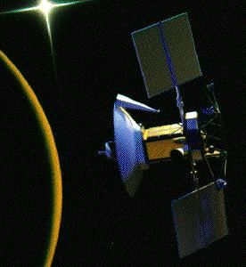 Magellan Credit: NASA |
Status: Operational 1989. First Launch: 1989-05-04. Last Launch: 1989-05-04. Number: 1 . Gross mass: 3,444 kg (7,592 lb). Height: 6.40 m (20.90 ft). Span: 9.20 m (30.10 ft).
At the completion of radar mapping 98% of the surface was imaged at resolutions better than 100 m, and many areas were imaged multiple times. Additional studies included measurements of surface altitude using radar altimetry and measurements of the planet's gravitational field using precision radio tracking. The mission was divided up into "cycles", each cycle lasted 243 days (the time necessary for Venus to rotate once under the Magellan orbit - i.e. the time necessary for Magellan to "see" the entire surface once.)
The Magellan mission scientific objectives were to study land forms and tectonics, impact processes, erosion, deposition, chemical processes, and model the interior of Venus. A total of 4225 usable SAR imaging orbits were obtained. Each orbit typically covered an area 20 km wide by 17,000 km long, at a resolution of 75 m/pixel. This raw SAR data was processed into image strips called full-resolution basic image data records (F-BIDRs). Adjacent F-BIDRs were then assembled into full-resolution mosaicked image data records (F-MIDRs). These images were then compressed once (by a factor of 3), twice (9), or 3 times (27), to give C1-, C2-, and C3-MIDRs.
The spacecraft was 3-axis stabilized using 3 reaction wheels. A 3.7 m diameter high gain antenna was used for both telecommunications and radar. Attitude sensors included 2 cruise sun sensors, 1 star scanner, and 2 inertial reference units. The power system included a 12.5 m2 solar array (1029 W EOL) and NiCd batteries (2 x 30 AHr). The hydrazine propulsion system had 0.9 N and 445 N thrusters. X-band (20 W) and S-Band (5 W) communications were provided with downlink rates of 268.8 or 115 kbps. Uplink rates were 31.25 and 62.5 bps.
A single radar instrument operated simultaneously as a Synthetic Aperture Radar (SAR), altimeter, and radiometer. Radar frequency was 2.385 GHz, with 325 W peak power and 25 km swath width (variable). Altimeter resolution was 30 m. Radiometer accuracy was 2 deg C. SAR resolution was 150 m (range and azimuth). An X- and S- band radio subsystem precisely tracked the spacecraft's orbit to make measurements of the gravity field.
Original name of the project was the Venus Orbiting Imaging Radar. Hughes supplied the radar mapper, and Martin the satellite.
NASA NSSDC Master Catalog Description
Magellan was a unique mission, the first dedicated U.S. mission to study in detail, using Synthetic Aperture Radar (SAR), the surface of Venus. Because Magellan was intended to be a low cost mission, major components of the spacecraft were obtained from flight spares from other programs including Galileo, Viking, Voyager, Mariner, Skylab, Ulysses, and even the shuttle. Designed as a follow-up to the mapping portion of the Pioneer Venus mission, Magellan's purpose was to: (1) obtain near-global radar images of Venus' surface with a resolution equivalent to optical imaging of 1 km per line pair; (2) obtain a near-global topographic map with 50 km spatial and 100 m vertical resolution; (3) obtain near-global gravity field data with 700 km resolution and 2--3 milligals (1 gal = 1 cm/s**2) accuracy; and, (4) develop an understanding of the geological structure of the planet, including its density distribution and dynamics.
Spacecraft and Subsystems
The spacecraft consisted primarily of a large (3.7 m) high-gain antenna dish which served the dual purpose of communications and science instrument for the SAR. The spacecraft was about 6.4 m long and, with the solar panels extended, about 9.2 m across. Behind the dish was a rectangular section containing the radar sensor electronics, reaction wheels, and batteries. Behind this section lay a decahedral bus, which included the solar panel array, star scanner, a medium-gain antenna, the on-board computer and two tape recorders. Behind the bus lay the propulsion module. The two 5.8 m solar panels were used for powering the spacecraft and charging the spacecraft's nickel-cadmium batteries. These batteries provided the 28 V of power needed during solar occultation to allow normal spacecraft operations. Pointing control was maintained through the use of three electrically powered, orthogonal reaction wheels. Large scale orbital corrections, both in transit to Venus as well as after orbital insertions, was accomplished through the use of a monopropellant (hydrazine) thruster system. The thrusters were also used to permit desaturation of the momentum wheels. The coherent X- and S-band radio subsystem was used for communications as well as by the gravity field experiment.
Mission Profile
Magellan reached Venus and went into orbit on 10 August 1990. The initial phase of the mission (Cycle 1) began shortly after orbital insertion about Venus and lasted for eight months (15 Sept. 1990--15 May 1991). During this cycle, Magellan collected radar images of about 84% of the planet's surface. Cycle 2 lasted from the end of cycle 1 until 15 Jan. 1992, during which the spacecraft obtained images of the southern polar region and filled numerous gaps left in cycle 1 information. Cycle 3 began on 24 Jan. 1992 and lasted until 15 Sept. 1992, during which the remaining gaps from cycle 1 were filled in as well as providing data which, in combination with earlier data, could be used to produce stereo images of the surface. Cycle 4 lasted from 15 Sept. 1992 to May 1993 and consisted of gravity data acquisition from the elliptical orbit. An aerobraking maneuver, in which Magellan was dipped into the Venus atmosphere to shed orbital energy and bring the spacecraft into a more circular orbit, was performed from 24 May until 02 August 1993. At the end of aerobraking, the orbit had a periapsis of 180 km, an apoapsis of 540 km, and a period of 94 minutes. Cycle 5 was used to acquire gravity from this orbit from 03 August 1993 until 29 August 1994, giving high-resolution gravity data for about 95% of the planet. In September, 1994 the Windmill experiment took place, in which the solar panels were tilted at an angle so that atmospheric drag put a torque on the craft, which could be measured to give information about the atmospheric density at different altitudes.
Magellan began its final descent into the Venus atmosphere on 11 October 1994. On 12 October radio contact was lost, and the spacecraft presumably burned up in the atmosphere on 13 or 14 October 1994. By the end of the mission, over 99% of the planet's surface had been mapped with a resolution ten times better than that obtained by the earlier Soviet Venera 15 and 16 missions.
The total cost of the mission through 29 October 1991 was $551 million, consisting of $287 million for the spacecraft, $120 million for the radar system, $49 million for launch and operations through the first 30 days, and $95 million for mission operations and data analysis. The approximate additional cost of operations and analysis through the end of the mission (29 October 1991 to 12 October 1994) was $130 million, bringing the overall cost to roughly $680 million.
More at: Magellan.
Family: Venus. Country: USA. Engines: Star 48B. Launch Vehicles: Space Shuttle. Launch Sites: Cape Canaveral, Cape Canaveral LC39B. Agency: JPL, NASA, Martin. Bibliography: 2, 296, 3866, 3867, 3868, 3869, 3870, 6.
 | Magellan Credit: Manufacturer Image |
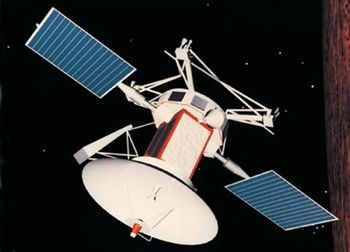 | Magellan Credit: Manufacturer Image |
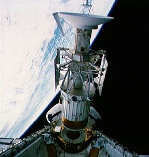 | STS-30 STS-30 Magellan spacecraft & IUS deployment from Atlantis' payload bay (PLB) Credit: NASA |
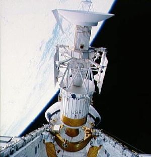 | STS-30 STS-30 Magellan spacecraft & IUS deployment from Atlantis' payload bay (PLB) Credit: NASA |
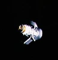 | STS-30 IUS with Magellan spacecraft drifts into space after STS-30 deployment Credit: NASA |
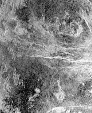 | STS-30 Magellan radar image compared to high resolution Earth-based image of Venus Credit: NASA |
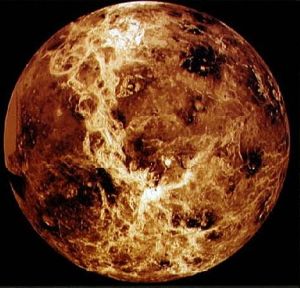 | STS-30 Global view of Venus from Magellan, Pioneer, and Venera data Credit: NASA |
1989 May 4 - . 18:47 GMT - . Launch Site: Cape Canaveral. Launch Complex: Cape Canaveral LC39B. Launch Platform: MLP1. LV Family: Shuttle. Launch Vehicle: Space Shuttle.
- Magellan - .
Payload: Atlantis F4 / Magellan [IUS]. Mass: 3,444 kg (7,592 lb). Nation: USA.
Agency: JPL,
NASA.
Class: Venus.
Type: Venus probe. Spacecraft: Magellan.
Decay Date: 1994-10-12 . USAF Sat Cat: 19969 . COSPAR: 1989-033B.
SAR radar imaging of the Venusian surface, gravitational field mapping. The Magellan spacecraft was deployed from shuttle STS-30 on May 5, 1989, arrived at Venus on August 10, 1990 and was inserted into a near-polar elliptical orbit with a periapsis altitude of 294 km at 9.5 deg. N. The primary objectives of the Magellan mission were to map the surface of Venus with a synthetic aperture radar (SAR) and to determine the topographic relief of the planet. At the completion of radar mapping 98% of the surface was imaged at resolutions better than 100 m, and many areas were imaged multiple times. The mission was divided up into 'cycles', each cycle lasted 243 days (the time necessary for Venus to rotate once under the Magellan orbit - i.e. the time necessary for Magellan to 'see' the entire surface once.) The mission proceeded as follows: 10 Aug 1990 - Venus orbit insertion and spacecraft checkout;15 Sep 1990 - Cycle 1: Radar mapping (left-looking); 15 May 1991 - Cycle 2: Radar mapping (right-looking); 15 Jan 1992 - Cycle 3: Radar mapping (left-looking); 14 Sep 1992 - Cycle 4: Gravity data acquisition; 24 May 1993 - Aerobraking to circular orbit; 3 Aug 1993 - Cycle 5: Gravity data acquisition; 30 Aug 1994 - Windmill experiment; 12 Oct 1994 - Loss of radio signal; 13 Oct 1994 - Loss of spacecraft. A total of 4225 usable SAR imaging orbits was obtained by Magellan. Magellan showed an Earth-sized planet with no evidence of Earth-like plate tectonics. At least 85% of the surface is covered with volcanic flows, the remainder by highly deformed mountain belts. Even with the high surface temperature (475 C) and high atmospheric pressure (92 bars), the complete lack of water makes erosion a negligibly slow process, and surface features can persist for hundreds of millions of years. Some surface modification in the form of wind streaks was observed. Over 80% of Venus lies within 1 km of the mean radius of 6051.84 km. The mean surface age is estimated to be about 500 million years. A major unanswered question concerns whether the entire surface was covered in a series of large events 500 million years ago, or if it has been covered slowly over time. The gravity field of Venus is highly correlated with the surface topography, which indicates the mechanism of topographic support is unlike the Earth, and may be controlled by processes deep in the interior. Details of the global tectonics on Venus were still unresolved.
1990 August 10 - .
1994 October 12 - .
Back to top of page
Home - Search - Browse - Alphabetic Index: 0- 1- 2- 3- 4- 5- 6- 7- 8- 9
A- B- C- D- E- F- G- H- I- J- K- L- M- N- O- P- Q- R- S- T- U- V- W- X- Y- Z
© 1997-2019 Mark Wade - Contact
© / Conditions for Use