Home - Search - Browse - Alphabetic Index: 0- 1- 2- 3- 4- 5- 6- 7- 8- 9
A- B- C- D- E- F- G- H- I- J- K- L- M- N- O- P- Q- R- S- T- U- V- W- X- Y- Z
Landsat 4-5
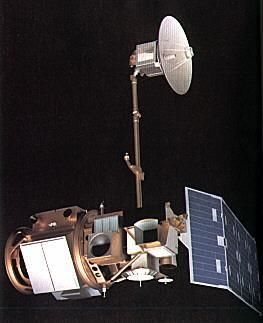
 Landsat 4 Credit: NASA |
Status: Operational 1982. First Launch: 1982-07-16. Last Launch: 1984-03-01. Number: 2 . Gross mass: 1,940 kg (4,270 lb). Height: 4.30 m (14.10 ft).
The Landsat 4 and 5 operational civilian earth resource spacecraft were placed into lower orbits than the previous Landsat spacecraft and carried improved instrument suites.
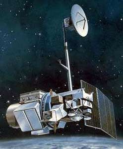
Beginning in 1983, Landsat 4 lost use of half its solar power and began experiencing numerous spacecraft malfunctions which limited spacecraft functionality. This prompted the early launch of Landsat 5 to guarantee continued coverage. Landsat 5 lost two of its primary communications systems (X-Band downlink and a Ku-Band TDRSS transponder) and backup systems were activated. Management of the spacecraft was transferred from NASA to NOAA with Landsat 4. The spacecraft was 3-axis stabilized, zero momentum with control to 0.01 deg using reaction wheels, and had a structure of aluminum with graphite struts. A hydrazine propulsion system was used, and a single solar array with 1-axis articulation produced 1430 W (BOL), Two NiCd batteries provided 100 AHr total. A retractable boom (4 m long) with 2 powered joints supported the articulated high gain antenna which downlinked data via TDRSS. The communications system used S, X, L, and Ku-Bands.
Landsat 4 and 5 carried Multi-Spectral Scanner (MSS) and Thematic Mapper (TM) imaging sensors. TM provided 7 bands of coverage and the MSS had 4 bands. The MSS covered 0.5 to 12.6 µ m and provided 80 m resolution with a 185 km swath width. TM covered 0.45 to 12.5 µ m with resolution of 30 meters in the VIS/IR bands and 120 m in the thermal/IR bands.
More at: Landsat 4-5.
Family: Earth, Earth land resource sat, Sun synchronous orbit. Country: USA. Spacecraft: Landsat. Launch Vehicles: Thor, Delta, Delta 3920, Delta 3000. Launch Sites: Vandenberg, Vandenberg SLC2W. Agency: NASA, NOAA, Astro Space, Fairchild. Bibliography: 2, 279, 6, 12755.
 | Landsat 4 Credit: Manufacturer Image |
1982 July 16 - . 17:59 GMT - . Launch Site: Vandenberg. Launch Complex: Vandenberg SLC2W. LV Family: Thor. Launch Vehicle: Delta 3920.
- Landsat 4 - . Payload: Landsat D. Mass: 1,942 kg (4,281 lb). Nation: USA. Agency: NASA Greenbelt. Program: Landsat. Class: Earth. Type: Earth resources satellite. Spacecraft Bus: MMS. Spacecraft: Landsat 4-5. USAF Sat Cat: 13367 . COSPAR: 1982-072A. Apogee: 705 km (438 mi). Perigee: 693 km (430 mi). Inclination: 98.20 deg. Period: 98.80 min. Spacecraft engaged in practical applications and uses of space technology such as weather or communication (US Cat C)..
1984 March 1 - . 17:59 GMT - . Launch Site: Vandenberg. Launch Complex: Vandenberg SLC2W. LV Family: Thor. Launch Vehicle: Delta 3920.
- Landsat 5 - . Payload: Landsat D'. Mass: 1,938 kg (4,272 lb). Nation: USA. Agency: NOAA. Program: Landsat. Class: Earth. Type: Earth resources satellite. Spacecraft Bus: MMS. Spacecraft: Landsat 4-5. USAF Sat Cat: 14780 . COSPAR: 1984-021A. Apogee: 703 km (436 mi). Perigee: 702 km (436 mi). Inclination: 98.20 deg. Period: 98.80 min. Spacecraft engaged in practical applications and uses of space technology such as weather or communication (US Cat C)..
Back to top of page
Home - Search - Browse - Alphabetic Index: 0- 1- 2- 3- 4- 5- 6- 7- 8- 9
A- B- C- D- E- F- G- H- I- J- K- L- M- N- O- P- Q- R- S- T- U- V- W- X- Y- Z
© 1997-2019 Mark Wade - Contact
© / Conditions for Use