Home - Search - Browse - Alphabetic Index: 0- 1- 2- 3- 4- 5- 6- 7- 8- 9
A- B- C- D- E- F- G- H- I- J- K- L- M- N- O- P- Q- R- S- T- U- V- W- X- Y- Z
TRMM
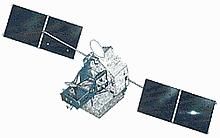
 TRMM Credit: NASDA |
AKA: Tropical Rainfall Measuring Mission. Status: Operational 1997. First Launch: 1997-11-27. Last Launch: 1997-11-27. Number: 1 . Gross mass: 3,620 kg (7,980 lb).
TRMM provided long-term data sets of rainfall and energy budget measurements which were to be used to better understand global climate changes and their mechanisms. The spacecraft and four instruments were provided by the USA, while Japan provided one instrument and launch services.
The latent heat released by tropical rainfall played a major role in the global atmospheric circulation and the energy budget. The large spatial and temporal variations in tropical rain made it particularly difficult to measure from the Earth's surface, and TRMM provided measurement accuracies possible only from an orbiting platform.
The spacecraft was 3-axis stabilized, with zero momentum bias. Two solar panels provided 1100 W. Data downlink was via TDRSS.
The payload consisted of:
- Clouds and the Earth's Radiant Energy System (CERES) - a passive broadband scanning radiometer with 3 spectral bands (visible through IR) that measured the Earth's radiation budget and atmospheric radiation from the top of the atmosphere to the surface of the Earth.
- Lightning Imaging Sensor (LIS) - an optical telescope and filter imaging system which investigated the distribution and variability of both intracloud and cloud-to-ground lightning over the earth. Data from this experiment allowed for the derivation of a lightning climatology over the tropics and related the lightning observations to the rainfall distribution in tropical systems.
- Precipitation Radar (PR) - the first spaceborne rain radar in the world, PR's major objectives were to (1) provide 3-dimensional rainfall structure data, (2) provide quantitative rainfall measurements, and (3) improve the accuracy of TRMM Microwave Imager (TMI) measurement by providing rain structure information. This phased array radar operated at 13.8 Ghz with a swath width of 215 km.
- TRMM Microwave Imager (TMI) - a multi-channel/dual-polarized microwave radiometer that provided data related to rainfall rates over the oceans. TMI data, together with PR data, formed the primary data set of precipitation measurement. The imager operated at 10.7, 19.4, 21.3, 37 and 85.5 Ghz, had a swath width of 760 km and provided 6-50 km horizontal resolution.
- Visible Infrared Scanner (VIRS) - a passive cross-track scanning radiometer which measured scene radiance in five spectral bands (visible through infrared). VIRS had a 720 km swath width and provides 2 km horizontal resolution.
Project total cost was $ 650 million.
More at: TRMM.
Family: Atmosphere sat, Earth. Country: USA. Launch Vehicles: H-II. Launch Sites: Tanegashima, Tanegashima Y. Agency: NASA, NASA Greenbelt, NASDA. Bibliography: 2, 4, 4184, 4185, 6995, 13297.
 | TRMM Credit: Manufacturer Image |
1997 November 27 - . 21:27 GMT - . Launch Site: Tanegashima. Launch Complex: Tanegashima Y. LV Family: H-2. Launch Vehicle: H-II.
- TRMM - . Nation: USA. Agency: NASA Greenbelt. Class: Earth. Type: Atmosphere satellite. Spacecraft: TRMM. Decay Date: 2015-06-16 . USAF Sat Cat: 25063 . COSPAR: 1997-074A. Apogee: 403 km (250 mi). Perigee: 395 km (245 mi). Inclination: 35.00 deg. Period: 92.50 min. TRMM was an international mission dedicated to measuring tropical and subtropical rainfall. The spacecraft and four instruments were provided by the USA, while Japan provided one instrument and launch services..
Back to top of page
Home - Search - Browse - Alphabetic Index: 0- 1- 2- 3- 4- 5- 6- 7- 8- 9
A- B- C- D- E- F- G- H- I- J- K- L- M- N- O- P- Q- R- S- T- U- V- W- X- Y- Z
© 1997-2019 Mark Wade - Contact
© / Conditions for Use