Home - Search - Browse - Alphabetic Index: 0- 1- 2- 3- 4- 5- 6- 7- 8- 9
A- B- C- D- E- F- G- H- I- J- K- L- M- N- O- P- Q- R- S- T- U- V- W- X- Y- Z
Mariner 8-9
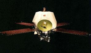
 Mariner 8, 9 Credit: NASA |
Status: Operational 1971. First Launch: 1971-05-09. Last Launch: 1971-05-30. Number: 2 . Gross mass: 985 kg (2,171 lb). Height: 0.44 m (1.44 ft).
The launch failure of Mariner 8 forced Mariner 9 to combine the mission objectives of both. The mission exceeded all primary photographic requirements by photo-mapping 100 percent of the planet's surface and taking the first close-up photographs of Mars' moons Deimos and Phobos. The spacecraft returned a total of 7329 images before it was turned off 349 days after entering orbit. The total cost of the mission was $137 million.
The Mariner 9 spacecraft was built on an octagonal magnesium frame, 45.7 cm deep and 138.4 cm across diagonally. Four solar panels, each 215 x 90 cm, extended out from the top of the frame. Each set of two solar panels spanned 6.89 meters from tip to tip. Also mounted on the top of the frame were two propulsion tanks, the maneuver engine, a 1.44 m long low gain antenna mast and a parabolic high gain antenna. A scan platform was mounted on the bottom of the frame, on which were attached the mutually bore-sighted science instruments (wide- and narrow-angle TV cameras, infrared radiometer, ultraviolet spectrometer, and infrared interferometer spectrometer). The overall height of the spacecraft was 2.28 m. The launch mass was 997.9 kg, of which 439.1 kg were expendables. The science instrumentation had a total mass of 63.1 kg. The electronics for communications and command and control were housed within the frame.
Spacecraft power was provided by a total of 14,742 solar cells which made up the 4 solar panels with a total area of 7.7 square meters. The solar panels could produce 800 W at Earth and 500 W at Mars. Power was stored in a 20 amp-hr nickel-cadmium battery. Propulsion was provided by a gimbaled engine capable of 1340 N thrust and up to 5 restarts. The propellant was monomethyl hydrazine and nitrogen tetroxide. Two sets of 6 attitude control nitrogen jets were mounted on the ends of the solar panels. Attitude knowledge was provided by a Sun sensor, a Canopus star tracker, gyroscopes, an inertial reference unit, and an accelerometer. Passive thermal control was achieved through the use of louvers on the eight sides of the frame and thermal blankets.
Spacecraft control was through the central computer and sequencer which had an onboard memory of 512 words. The command system was programmed with 86 direct commands, 4 quantitative commands, and 5 control commands. Data was stored on a digital reel-to-reel tape recorder. The 168 meter 8-track tape could store 180 million bits recorded at 132 kbits/s. Playback could be done at 16, 8, 4, 2, and 1 kbit/s using two tracks at a time. Telecommunications were via dual S-band 10 W/20 W transmitters and a single receiver through the high gain parabolic antenna, the medium gain horn antenna, or the low gain omnidirectional antenna.
Payload
Scan platform supported an infrared radiometer, wide-angle TV, ultraviolet spectrometer, narrow-angle TV (1-2 km resolution), and IR interferometric spectrometer. The scan platform articulated 215 deg in azimuth and 69 deg in elevation.
More at: Mariner 8-9.
Family: Mars orbiter. Country: USA. Engines: RS-2101. Launch Vehicles: Atlas, Mars tactical rocket, Atlas SLV-3C Centaur. Projects: Mariner, Mars. Launch Sites: Cape Canaveral, Cape Canaveral LC36A, Cape Canaveral LC36B. Agency: JPL, NASA. Bibliography: 126, 2, 278, 296, 3895, 3900, 3901, 3902, 6, 12797.
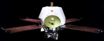
 | Mariner 8 Credit: Manufacturer Image |
1971 May 9 - . 01:11 GMT - . Launch Site: Cape Canaveral. Launch Complex: Cape Canaveral LC36A. LV Family: Atlas. Launch Vehicle: Atlas SLV-3C Centaur. FAILURE: Inadvertent Centaur electronic signal shut down stage early.. Failed Stage: U.
- Mariner H - . Payload: Mariner 71H. Mass: 996 kg (2,195 lb). Nation: USA. Agency: NASA. Program: Mariner. Class: Mars. Type: Mars probe. Spacecraft Bus: Mariner. Spacecraft: Mariner 8-9. Decay Date: 1971-05-08 . Intended Mars flyby..
1971 May 30 - . 22:23 GMT - . Launch Site: Cape Canaveral. Launch Complex: Cape Canaveral LC36B. LV Family: Atlas. Launch Vehicle: Atlas SLV-3C Centaur.
- Mariner 9 - .
Payload: Mariner 71J. Mass: 974 kg (2,147 lb). Nation: USA.
Agency: JPL,
NASA.
Program: Mariner.
Class: Mars.
Type: Mars probe. Spacecraft Bus: Mariner.
Spacecraft: Mariner 8-9.
USAF Sat Cat: 5261 . COSPAR: 1971-051A.
The first spacecraft to orbit another planet. The Mariner Mars 71 mission was planned to consist of two spacecraft on complementary missions. Mariner 8 was to map 70 % of the Martian surface and Mariner 9 was to study temporal changes in the Martian atmosphere and on the Martian surface. The launch failure of Mariner 8 forced Mariner 9 to combine the mission objectives of both. For the survey portion of the mission, the planetary surface was to be mapped with the same resolution as planned for the original mission, although the resolution of pictures of the polar regions would be decreased due to the increased slant range. The variable features experiments were changed from studies of six given areas every 5 days to studies of smaller regions every 17 days. Mariner 9 was launched on a direct trajectory to Mars. Separation from the booster occurred at 22:36 GMT. The four solar panels were deployed at 22:40 GMT. The sensors locked onto the Sun at 23:16, shortly after the spacecraft left the Earth's shadow and Canopus acquisition was achieved at 02:26 GMT 31 May. A planned midcourse maneuver was executed on 5 June. Mariner 9 arrived at Mars on 14 November 1971 after a 167 day flight. A 15 minute 23 second rocket burn put the spacecraft into Mars orbit. The insertion orbit had a periapsis of 1398 km and a period of 12 hr, 34 min. Two days later a 6 second rocket burn changed the orbital period to just under 12 hours with a periapsis of 1387 km. A correction trim maneuver was made on 30 December on the 94th orbit which raised the periapsis to 1650 km and changed the orbital period to 11:59:28 so that synchronous data transmissions could be made to the Goldstone 64-m DSN antenna.
Imaging of the surface of Mars by Mariner 9 was delayed by a dust storm which started on 22 September 1971 in the Noachis region. The storm quickly grew into one of the largest global storms ever observed on Mars. By the time the spacecraft arrived at Mars no surface details could be seen except the summits of Olympus Mons and the three Tharsis volcanoes. The storm abated through November and December and normal mapping operations began. The spacecraft gathered data on the atmospheric composition, density, pressure, and temperature and also the surface composition, temperature, gravity, and topography of Mars. A total of 54 billion bits of scientific data were returned, including 7329 images covering the entire planet. After depleting its supply of attitude control gas, the spacecraft was turned off on 27 October 1972. Mariner 9 was left in an orbit which should not decay for at least 50 years, after which the spacecraft will enter the Martian atmosphere.
The Mariner 9 mission resulted in a global mapping of the surface of Mars, including the first detailed views of the martian volcanoes, Valles Marineris, the polar caps, and the satellites Phobos and Deimos. It also provided information on global dust storms, the gravity field as well as evidence for surface aeolian activity.
1971 November 14 - .
- Mariner 9, Mars Orbit Insertion - . Nation: USA. Spacecraft Bus: Mariner. Spacecraft: Mariner 8-9.
Back to top of page
Home - Search - Browse - Alphabetic Index: 0- 1- 2- 3- 4- 5- 6- 7- 8- 9
A- B- C- D- E- F- G- H- I- J- K- L- M- N- O- P- Q- R- S- T- U- V- W- X- Y- Z
© 1997-2019 Mark Wade - Contact
© / Conditions for Use