Home - Search - Browse - Alphabetic Index: 0- 1- 2- 3- 4- 5- 6- 7- 8- 9
A- B- C- D- E- F- G- H- I- J- K- L- M- N- O- P- Q- R- S- T- U- V- W- X- Y- Z
MAP
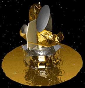
 MAP Credit: Manufacturer Image |
Status: Operational 2001. First Launch: 2001-06-30. Last Launch: 2001-06-30. Number: 1 . Gross mass: 840 kg (1,850 lb). Unfuelled mass: 768 kg (1,693 lb).
It measured fluctuations in the cosmic 3 Kelvin microwave background down to 35 microKelvin on scales down to 0.2 degrees. Ground-based experiments had provided convincing evidence that these background fluctuations were consistent with a model in which the total density of the universe was closely equal to the critical density; MAP was designed to refine and extend these observations. The spacecraft had a dry mass of 768 kg and carried 72 kg of propellant. It was built at NASA-Goddard, and the microwave instrument was built in collaboration with Princeton University. MAP was the second MIDEX mid-sized Explorer - the first was IMAGE, which studied the magnetosphere. The third MIDEX was to be SWIFT, for gamma ray burst studies, due for launch in 2003.
The 400 W MAP probe was to scan the sky in five wavelength bands at 13.6, 10.0, 7.5, 5.0, and 3.3 mm at an angular resolution of about 0.58 (+/- 0.035) deg, and at a sensitivity of 35 micro-Kelvin after "parking" itself over the second Lagrangian point (L-2) at 1.5 million km in the nightside. These parameters were invoked on the basis of the anisotropy in the 2.7 deg Kelvin cosmic radiation revealed by the earlier mission, COBE. It carried two Gregorian telescopes each with a primary reflector of about 1.5 m and a secondary of 1.0 m diameter. The two telescopes were to point to the sky a few degrees apart so that the difference in the temperature could be directly outputted. (One of the branches of cosmology invokes an early "inflationary" epoch of spurious super-expansion of the "Big Bang" fireball giving rise to a small anisotropy that eventually gave birth to the galactic structures in the otherwise mathematically homogenous and isotropic universe.) The spacecraft had an intrinsic spin of 0.464 rpm superposed on a precession (22.5 deg about the Sun-MAP line) of 1.0 rph. A full-sky map could be obtained every six months. MAP was to reach L-2 after three or more lunar encounters/phasings, and enter into a controlled Lissajous orbit around that point with a maximum deviation of the Sun-MAP line from the Sun-Earth line of 10 deg. About four thrust maneuvers/year were required to sustain the orbit configuration.
More at: MAP.
Family: Astronomy, Infrared astronomy satellite. Country: USA. Launch Vehicles: Thor, Delta, Delta 2 7000, Delta 7425-10. Launch Sites: Cape Canaveral, Cape Canaveral LC17B. Agency: NASA Greenbelt. Bibliography: 2, 296, 3960, 3961, 12787.
2001 June 30 - . 19:46 GMT - . Launch Site: Cape Canaveral. Launch Complex: Cape Canaveral LC17B. Launch Pad: SLC17B. LV Family: Thor. Launch Vehicle: Delta 7425-10.
- MAP - .
Mass: 840 kg (1,850 lb). Nation: USA.
Agency: NASA Greenbelt.
Class: Astronomy.
Type: Infrared astronomy satellite. Spacecraft: MAP.
USAF Sat Cat: 26859 . COSPAR: 2001-027A. Apogee: 379,553 km (235,842 mi). Perigee: 4,704 km (2,922 mi). Inclination: 27.80 deg. Period: 14,669.70 min.
NASA's Microwave Anisotropy Probe (MAP) was placed in a 167 x 204 km x 28.8 deg parking orbit at 1958 GMT. At 2104 GMT the second stage ignited again for a 4 second burn, raising the orbit to around 181 x 308 km; the third stage spun up and ignited at 2108 GMT, accelerating MAP to a highly elliptical orbit of 182 x 292,492 km x 28.7 deg. MAP used on-board fuel to tweak the orbit and make a lunar flyby at fourth apogee on July 30, arriving at the L2 Earth-Moon Lagrangian point 1.5 million km from Earth three months later. From L2, MAP was to measure fluctuations in the cosmic 3 Kelvin microwave background with the degree of precision required to answer questions about the big bang and the total mass and fate of the universe. By July 22 the MAP probe was in a 4055 x 355,935 km x 28.0 deg orbit. It flew past the Moon on July 30 at 1639 GMT at an altitude of 5200 km above the lunar surface.
2001 July 30 - .
- MAP, Moon Flyby - . Spacecraft: MAP.
Back to top of page
Home - Search - Browse - Alphabetic Index: 0- 1- 2- 3- 4- 5- 6- 7- 8- 9
A- B- C- D- E- F- G- H- I- J- K- L- M- N- O- P- Q- R- S- T- U- V- W- X- Y- Z
© 1997-2019 Mark Wade - Contact
© / Conditions for Use