Home - Search - Browse - Alphabetic Index: 0- 1- 2- 3- 4- 5- 6- 7- 8- 9
A- B- C- D- E- F- G- H- I- J- K- L- M- N- O- P- Q- R- S- T- U- V- W- X- Y- Z
Tongchang-ri
 |
AKA: Sohae. Longitude: 124.71 deg. Latitude: 39.66 deg.
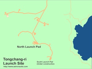
The site consists of two primary launch pads, a launch control center, fuel farms, storage warehouses, and other support facilities. The northern pad was operational in April 2012. The second, southern pad, was still under construction at that time.
In the NOTAM (notice to airmen) issued by North Korea on 19 March 2012, the impact zones of the first and second stages were given as 480 km and 2500 km directly south of the launch site.
Country: Korea North.
2012 April 12 - . 22:39 GMT - . Launch Site: Tongchang-ri. LV Family: Unha. Launch Vehicle: Unha-3. FAILURE: Failed at second stage separation..
- Kwangmyongsong-3 - .
Mass: 100 kg (220 lb). Nation: Korea North.
Class: Technology.
Type: Technology satellite. Spacecraft: Kwangmyongsong.
Third North Korean satellite launch attempt, conducted despite international protests (that attempted to connect it with the country's missile program). Launched from a new site on the west coast of Korea on a southwest trajectory, to achieve a polar orbit and also avoid overflying Japan. Failed at first stage separation. Unusually North Korea provided the western press access to the launch site prior to the attempt, and admitted the launch failure after the fact.
2012 December 12 - . 00:49 GMT - . Launch Site: Tongchang-ri. LV Family: Unha. Launch Vehicle: Unha-3.
- Kwangmyongsong-3F2 - .
Mass: 100 kg (220 lb). Nation: Korea North.
Class: Technology.
Type: Technology satellite. Spacecraft: Kwangmyongsong.
USAF Sat Cat: 39026 . COSPAR: 2012-072A. Apogee: 581 km (361 mi). Perigee: 498 km (309 mi). Inclination: 97.40 deg. Period: 95.40 min.
First successful North Korean satellite launch. Amateur observations showed the satellite to be tumbling, and no signals were picked up at the announced 470 MHZ frequency - it was assumed the spacecraft never functioned or failed shortly after orbital insertion.
Back to top of page
Home - Search - Browse - Alphabetic Index: 0- 1- 2- 3- 4- 5- 6- 7- 8- 9
A- B- C- D- E- F- G- H- I- J- K- L- M- N- O- P- Q- R- S- T- U- V- W- X- Y- Z
© 1997-2019 Mark Wade - Contact
© / Conditions for Use