Home - Search - Browse - Alphabetic Index: 0- 1- 2- 3- 4- 5- 6- 7- 8- 9
A- B- C- D- E- F- G- H- I- J- K- L- M- N- O- P- Q- R- S- T- U- V- W- X- Y- Z
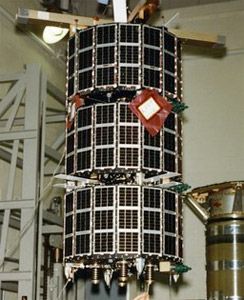
Stacksat P87-2
 USA 56 Credit: Manufacturer Image |
AKA: P87-2;POGS;SCE;TEX. Status: Operational 1990. First Launch: 1990-04-11. Last Launch: 1990-04-11. Number: 3 . Gross mass: 68 kg (149 lb).
The POGS (Polar Orbiting Geomagnetic Survey) satellite was designed to measure the Earth's magnetic field vector as a function of position for the Defense Mapping Agency. Data from the experiment would be used to improve Earth navigation systems, and was stored in an experimental Fairchild solid state recorder. TEX (Transceiver EXperiment) carried a variable power transmitter used to study ionospheric effects on RF transmissions. Data from the experiment would be used to determine minimum spacecraft transmitter power levels for transmission to ground receivers. SCE (Selective Communications Experiment) carried a variable frequency transmitter to study ionospheric effects at various RF frequencies, and was also designed to demonstrate message store and forward techniques. Six low cost ground stations were designed, built and located around the world to operate these spacecraft. The PDD Payload Deployment Device disbursed the satellites into their target orbits.
The spacecraft was gravity gradient stabilized. Body mounted solar arrays provided ~15W orbit average power. The satellite was built by Defense Systems Inc. (later CTA)
More at: Stacksat P87-2.
Family: Technology, Technology satellite. Country: USA. Launch Vehicles: Atlas, Atlas E Altair. Launch Sites: Vandenberg, Vandenberg SLC3W. Agency: USN, USAF, CTA Space Systems. Bibliography: 2, 278, 279, 6, 13201.
1990 April 11 - . 15:00 GMT - . Launch Site: Vandenberg. Launch Complex: Vandenberg SLC3W. LV Family: Atlas. Launch Vehicle: Atlas E Altair.
- USA 56 - .
Payload: POGS & SSR. Nation: USA.
Agency: USAF.
Class: Technology.
Type: Navigation technology satellite. Spacecraft Bus: MAESTRO.
Spacecraft: Stacksat P87-2.
USAF Sat Cat: 20560 . COSPAR: 1990-031A. Apogee: 745 km (462 mi). Perigee: 627 km (389 mi). Inclination: 89.80 deg. Period: 98.48 min.
Polar Orbiting Geomagnetic Survey satellite designed to measure the Earth's magnetic field vector as a function of position. Data from the experiment was used to improve Earth navigation systems, and was stored in an experimental solid state recorder. Six low cost ground stations were designed, built and located around the world to operate the spacecraft flown on this mission.
- USA 57 - . Payload: TEX. Nation: USA. Agency: USAF. Class: Technology. Type: Navigation technology satellite. Spacecraft Bus: MAESTRO. Spacecraft: Stacksat P87-2. USAF Sat Cat: 20561 . COSPAR: 1990-031B. Apogee: 742 km (461 mi). Perigee: 627 km (389 mi). Inclination: 89.80 deg. Period: 98.45 min. TEX (Transceiver EXperiment) carried a variable power transmitter used to study ionospheric effects on RF transmissions. Data from the experiment was used to determine minimum spacecraft transmitter power levels for transmission to ground receivers..
- USA 58 - . Payload: SCE. Nation: USA. Agency: USAF. Class: Technology. Type: Navigation technology satellite. Spacecraft Bus: MAESTRO. Spacecraft: Stacksat P87-2. USAF Sat Cat: 20562 . COSPAR: 1990-031C. Apogee: 741 km (460 mi). Perigee: 627 km (389 mi). Inclination: 89.80 deg. Period: 98.44 min. SCE (Selective Communications Experiment) carried a variable frequency transmitter to study ionospheric effects at various RF frequencies, and was also designed to demonstrate message store and forward techniques..
Back to top of page
Home - Search - Browse - Alphabetic Index: 0- 1- 2- 3- 4- 5- 6- 7- 8- 9
A- B- C- D- E- F- G- H- I- J- K- L- M- N- O- P- Q- R- S- T- U- V- W- X- Y- Z
© 1997-2019 Mark Wade - Contact
© / Conditions for Use