Home - Search - Browse - Alphabetic Index: 0- 1- 2- 3- 4- 5- 6- 7- 8- 9
A- B- C- D- E- F- G- H- I- J- K- L- M- N- O- P- Q- R- S- T- U- V- W- X- Y- Z
Seasat
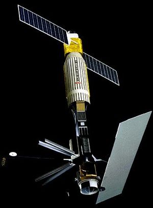
 Seasat Credit: NASA |
Status: Operational 1978. First Launch: 1978-06-27. Last Launch: 1978-06-27. Number: 1 . Gross mass: 2,300 kg (5,000 lb). Height: 21.00 m (68.00 ft).
The mission was designed to demonstrate the feasibility of global satellite monitoring of oceanographic phenomena and to help determine the requirements for an operational ocean remote sensing satellite system. Specific objectives were to collect data on sea-surface winds, sea-surface temperatures, wave heights, internal waves, atmospheric water, sea ice features and ocean topography. The mission ended on October 10, 1978 due to a failure of the vehicle's electric power system. Although only approximately 42 hours of real time data was received, the mission demonstrated the feasibility of using microwave sensors to monitor ocean conditions, and laid the groundwork for future SAR missions.
The spacecraft utilized the Agena upper stage to provide satellite bus functions, including power, telemetry (S-band), attitude control, and command and control functions. A sensor package containing the mission's five experiments was attached to the Agena, as were the experiments' antenna systems. The vehicle was 3-axis stabilized using momentum wheels and horizon sensors. The vehicle was oriented with the SAR and other antennas remaining nadir pointing and the Agena rocket nozzle and solar panels zenith pointing.
The payload included:
- Synthetic Aperture Radar (SAR) - used to image the ocean surface (wave patterns), polar ice caps, snow coverage, and coastal regions. The experiment operated at L-band (1.275 Ghz) with a 100 km swath, and provided 25 meter vertical resolution. The experiment used a 2.2 m x 10.7 m corporate feed antenna.
- Radar Altimeter (ALT) - used to measure wave heights by measuring spacecraft altitude above the ocean surface. The experiment operated at Ku-band and had 10 cm vertical accuracy.
- Seasat-A Satellite Scatterometer (SASS) - used to measure wind speed and direction. SASS operated at L-band (1.275 Ghz) and provided accuracies of +/- 2 m/s (speed) and 20 deg. (direction).
- Scanning Multichannel Microwave Radiometer (SMMR) - used to measure surface wind speed (+/- 2 m/s), ocean surface temperature (+/- 2 deg C), atmospheric water vapor content, rain rate, and ice coverage. The experiment was passive, and operated at 6.6, 18, 37, 10.7 and 21 Ghz with a 600 km swath width.
- Visible and IR Radiometer (VIRR) - used to identify cloud, land and water features (in support of the other instruments) and provide ocean thermal images. VIRR operated between 0.25-0.73 Ám and 10.5-12.5 Ám, and had a 1900 km swath width with an IFOV of 2-5 km.
More at: Seasat.
Family: Earth, Civilian radarsat. Country: USA. Engines: Bell 8096. Launch Vehicles: Atlas, Atlas F, Atlas F/Agena D. Launch Sites: Vandenberg, Vandenberg SLC3W. Agency: JPL, NASA, Lockheed, Ball. Bibliography: 2, 278, 279, 6, 6859, 13079.
 | Seasat 1 Credit: Manufacturer Image |
1978 June 27 - . 01:12 GMT - . Launch Site: Vandenberg. Launch Complex: Vandenberg SLC3W. LV Family: Atlas. Launch Vehicle: Atlas F/Agena D.
- Seasat 1 - .
Payload: Seasat A. Mass: 2,300 kg (5,000 lb). Nation: USA.
Agency: JPL,
NASA.
Class: Earth.
Type: Civilian Radarsat. Spacecraft: Seasat.
USAF Sat Cat: 10967 . COSPAR: 1978-064A. Apogee: 765 km (475 mi). Perigee: 761 km (472 mi). Inclination: 108.00 deg. Period: 100.10 min.
An Atlas booster launched SEASAT-A, a NASA satellite. The purpose of the mission was to evaluate the use of microwave instruments to obtain oceanographic data. The launch was successful, but the satellite ceased functioning because of an electrical short after 99 days of operation. Oceanographic. Spacecraft engaged in practical applications and uses of space technology such as weather or communication (US Cat C).
1978 October 10 - .
- Seasat fails - .
Nation: USA.
Spacecraft: Seasat.
Seasat was the first satellite designed for remote sensing of the Earth's oceans with synthetic aperture radar (SAR). The mission ended on October 10, 1978 due to a failure of the vehicle's electric power system. The suspicion exists that the satellite was intentionally shut off because the quality and nature of the results obtained alarmed the Pentagon.
Back to top of page
Home - Search - Browse - Alphabetic Index: 0- 1- 2- 3- 4- 5- 6- 7- 8- 9
A- B- C- D- E- F- G- H- I- J- K- L- M- N- O- P- Q- R- S- T- U- V- W- X- Y- Z
© 1997-2019 Mark Wade - Contact
© / Conditions for Use