
Home - Search - Browse - Alphabetic Index: 0- 1- 2- 3- 4- 5- 6- 7- 8- 9
A- B- C- D- E- F- G- H- I- J- K- L- M- N- O- P- Q- R- S- T- U- V- W- X- Y- Z
Phoenix Eye
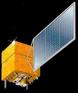 CBERS-1 ZY-1 FM1 Credit: Manufacturer Image |
AKA: Zi Yuan. Status: Operational 1999. First Launch: 1999-10-14. Last Launch: 2014-12-07. Number: 7 .
The design was split into the following subsystems: structure, attitude and orbit control, thermal control, power supply and TT&C. It was designed to accept a range of remote sensing equipment requiring high attitude control precision, maneuver capability, large data storage and high data transmission rate.
Technical Specifications
Total satellite mass: 1500 - 3000 kg
Dimensions: 1800 mm × 2000 mm × 2200~4600 mm (height adjustable according to payload requirement)
Payload capacity: 500 - 1200 kg
Operation orbit: sun synchronous orbit
Attitude control mode: 3-axis stabilized, earth-pointing
3-axis pointing error: <0.3 deg (3 sigma)
3-axis attitude stability: <5×10⁻⁴ deg /s (3 sigma)
3-axis attitude determination error: < 0.03 deg (3 sigma)
Solar array pointing error: 4.5 deg
Solar array output: 1200 - 2300 W (EOL)
Payload power: 700 - 1700 W
Designed lifetime: >4 years
Flight Experience: CBERS 01(1999), 02(2003), 02B(2007) and ZY-2 01(2000),
02(2002), 03(2004)
| CBERS 1, 2, 2B / ZY-1 01, 02, 02B Null |
| ZY Chinese earth land resources satellite. 6 launches, 1999.10.14 (ZY-1) to 2007.09.19 (ZY-2C). From 1985 China and Brazil jointly developed a sun synchronous imaging satellite bus, the Zi Yuan-1 (Resouce-1) based on the Shi Jian 3 design. |
| ZY-2 01, 02, 03 (JB-3 1, 2, 3) Null |
| Yaogan 5, 12, 21 (JB-10 1, 2, 3) Null |
| ZY-1 02C Earth Observation satellite operated by CEODE, China. Launched 2011. Used Phoenix-Eye-2 bus. |
| ZY-3 01, 02 Earth Observation satellite operated by State Bureau of Surveying and Mapping, China. Launched 2012 - 2016. Used Phoenix-Eye-2 bus. |
| Yaogan 14, 28 (JB-11 1, 2) Null |
| CBERS 3, 4, 4A / ZY-1 03, 04, 04A Null |
Family: Earth, Surveillance. Country: China. Launch Vehicles: Chang Zheng 4B. Launch Sites: Taiyuan LC9, Taiyuan LC1. Bibliography: 12950, 12951, 12952, 12953, 12954.
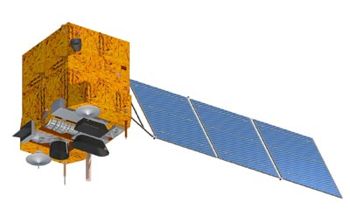 | CBERS-3 ZY-1 FM 3 Credit: Manufacturer Image |
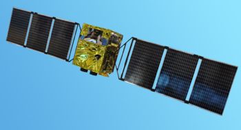 | ZY-1 02C Credit: Manufacturer Image |
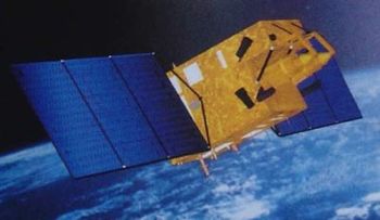 | ZY-2 Credit: Manufacturer Image |
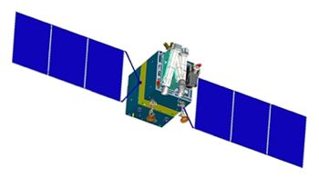 | ZY 3 Credit: Manufacturer Image |
1999 October 14 - . 03:15 GMT - . Launch Site: Taiyuan. Launch Complex: Taiyuan LC1. LV Family: CZ. Launch Vehicle: Chang Zheng 4B.
- CBERS-1 ZY-1 FM1 - .
Payload: Zi Yuan 1. Mass: 1,450 kg (3,190 lb). Nation: China.
Agency: SISE.
Manufacturer: CAST,
INP.
Class: Earth.
Type: Earth resources satellite. Spacecraft: Phoenix Eye.
USAF Sat Cat: 25940 . COSPAR: 1999-057A. Apogee: 780 km (480 mi). Perigee: 773 km (480 mi). Inclination: 98.20 deg. Period: 100.40 min.
China-Brazil Earth Resources Satellite. China's first earth resources satellite, known as ZY-1, weighed 1,540 kilograms. Chief designer was Chen Yiyuan. The satellite, a joint project of China and Brazil, was designed to gather information on the environment, agriculture and urban planning through remote sensing images and data transmitted to China, Brazil and other countries. Planned lifetime was two years. The satellite circled the Earth 14 times a day and the groundtrack repeated after 26 days. By 23 February 2000 it had taken more than 20,000 high quality images. It was formally handed over for operational use on March 2 2000. The High Resolution CCD Camera had a resolution of 20 meters in the visible spectrum. The camera could point up to 32 degrees to either side of vertical, imaging the earth's surface stereoscopically. After 177 days the Wide Field Imager failed in early May 2000. Other devices, including the high resolution CCD camera, continue to work normally.
2003 October 21 - . 03:16 GMT - . Launch Site: Taiyuan. Launch Complex: Taiyuan LC1. LV Family: CZ. Launch Vehicle: Chang Zheng 4B.
- CBERS-2 ZY-1 FM2 - . Payload: Zi Yuan 1B. Mass: 1,450 kg (3,190 lb). Nation: China. Agency: CAS. Class: Earth. Type: Earth resources satellite. Spacecraft: Phoenix Eye. USAF Sat Cat: 28057 . COSPAR: 2003-049A. Apogee: 750 km (460 mi). Perigee: 731 km (454 mi). Inclination: 98.50 deg. Period: 99.60 min. Delayed from late 2001, September 3 2002, March 14 and September 2003. Second China-Brazil Earth Resources Satellite (CBERS 2)..
2007 September 19 - . 03:26 GMT - . Launch Site: Taiyuan. LV Family: CZ. Launch Vehicle: Chang Zheng 4B.
- CBERS-2B ZY-1 FM2B - .
Mass: 1,452 kg (3,201 lb). Nation: Brazil,
China.
Agency: SISE.
Class: Surveillance.
Type: Civilian surveillance satellite. Spacecraft: Phoenix Eye.
USAF Sat Cat: 32062 . COSPAR: 2007-042A. Apogee: 775 km (481 mi). Perigee: 773 km (480 mi). Inclination: 98.50 deg. Period: 100.30 min.
Third China-Brazil joint earth resources satellite. Much higher resolution optics and multispectral sensors expected to be useful for some military applications as well. The satellite raised its orbit to its operational altitude of 773 km two days after launch.
2011 December 22 - . 03:26 GMT - . Launch Site: Taiyuan. LV Family: CZ. Launch Vehicle: Chang Zheng 4B.
- ZY-1 02C - . Mass: 2,100 kg (4,600 lb). Nation: China. Class: Surveillance. Type: Military surveillance satellite. Spacecraft: Phoenix Eye. USAF Sat Cat: 38038 . COSPAR: 2011-079A. Apogee: 775 km (481 mi). Perigee: 773 km (480 mi). Inclination: 98.50 deg. Period: 100.30 min. Military imaging payload with a resolution of 2.4 m..
2012 January 9 - . 03:17 GMT - . Launch Site: Taiyuan. LV Family: CZ. Launch Vehicle: Chang Zheng 4B.
- ZY 3 - .
Mass: 2,636 kg (5,811 lb). Nation: China.
Class: Surveillance.
Type: Military surveillance satellite. Spacecraft: Phoenix Eye.
USAF Sat Cat: 38046 . COSPAR: 2012-001A. Apogee: 508 km (315 mi). Perigee: 496 km (308 mi). Inclination: 97.50 deg. Period: 94.70 min.
First Chinese civil high-resolution stereoscopic Earth mapping satellite. The mission objective was to produce 1:50,000 scale maps and data for resource mapping, environmental surveying, disaster monitoring, city planning and national security needs. Project go-ahead was March 2008. For this mission the satellite had better positioning and attitude accuracy, multispectral capabilitym and high-data-rate data transmission to the ground - 2 x 450 Mbit/s. The satellite had a swath width of 51 km with a resolution of 2.1 m. The orbit provided a revisit period of 59 days.
2013 December 9 - . 03:26 GMT - . Launch Site: Taiyuan. Launch Pad: xxx. LV Family: CZ. Launch Vehicle: Chang Zheng 4B. FAILURE: Failed to reach orbit; third stage shut down 11 seconds early..
- CBERS-3 ZY-1 FM 3 - . Mass: 1,450 kg (3,190 lb). Nation: Brazil. Class: Surveillance. Type: Surveillance satellite. Spacecraft: Phoenix Eye. China-Brazil Earth Resources Satellite. It was initially reported the launch was a success, but in fact the CZ-4B rocket failed to reach orbit..
2014 December 7 - . 03:26 GMT - . Launch Site: Taiyuan LC9. Launch Complex: Taiyuan LC9. LV Family: CZ. Launch Vehicle: Chang Zheng 4B.
- CBERS-4 - . Mass: 2,100 kg (4,600 lb). Nation: China. Class: Surveillance. Type: Surveillance satellite. Spacecraft: Phoenix Eye. USAF Sat Cat: 40336 . COSPAR: 2014-079A. Apogee: 774 km (480 mi). Perigee: 773 km (480 mi). Inclination: 98.51 deg. Period: 100.32 min. China-Brazil Earth Resources Satellite 4. The uprated ZY-1 class satellite replaced CBERS 3 which was lost in a launch failure a year earlier. Sun synchronous orbit; 1030 GMT local time of the descending node..
Back to top of page
Home - Search - Browse - Alphabetic Index: 0- 1- 2- 3- 4- 5- 6- 7- 8- 9
A- B- C- D- E- F- G- H- I- J- K- L- M- N- O- P- Q- R- S- T- U- V- W- X- Y- Z
© 1997-2019 Mark Wade - Contact
© / Conditions for Use