Home - Search - Browse - Alphabetic Index: 0- 1- 2- 3- 4- 5- 6- 7- 8- 9
A- B- C- D- E- F- G- H- I- J- K- L- M- N- O- P- Q- R- S- T- U- V- W- X- Y- Z
Daichi
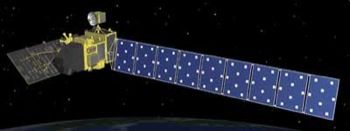
 Daichi Credit: Manufacturer Image |
AKA: Advanced Land Observing Satellite;ALOS. Status: Operational 2006. First Launch: 2006-01-24. Last Launch: 2006-01-24. Number: 1 . Gross mass: 3,850 kg (8,480 lb).
It carried an L-band synthetic aperture radar, an optical 2.5-meter resolution mapping camera, and a 10-meter resolution visible/near-infrared radiometer.
More at: Daichi.
| Daichi-2 Advanced Land Observing Satellite 2, placed in a noon/midnight sun-synchronous orbit. Carried the PALSAR-2 radar imager with 1 to 3 meter resolution in spotlight mode and 3 to 10 m in high resolution mode. |
Family: Civilian radarsat, Surveillance. Country: Japan. Launch Vehicles: H-II, H-IIA 2022. Launch Sites: Tanegashima, Tanegashima Y. Agency: NEC, JAXA. Bibliography: 2.
2006 January 24 - . 01:33 GMT - . Launch Site: Tanegashima. Launch Complex: Tanegashima Y. LV Family: H-2. Launch Vehicle: H-IIA 2022.
- Daichi - . Payload: ALOS-1. Mass: 3,850 kg (8,480 lb). Nation: Japan. Agency: JAXA. Manufacturer: Toshiba. Class: Surveillance. Type: Military Radarsat. Spacecraft: Daichi. USAF Sat Cat: 28931 . COSPAR: 2006-002A. Apogee: 697 km (433 mi). Perigee: 693 km (430 mi). Inclination: 98.20 deg. Period: 98.70 min. Advanced Land Observing Satellite, which carried an L-band synthetic aperture radar, an optical 2.5-meter resolution mapping camera, and a 10-meter resolution visible/near-infrared radiometer..
2014 May 24 - . 03:05 GMT - . Launch Site: Tanegashima. Launch Complex: Tanegashima Y. LV Family: H-2. Launch Vehicle: H-IIA 202.
- Daichi-2 - . Payload: ALOS 2. Mass: 2,120 kg (4,670 lb). Nation: Japan. Class: Surveillance. Type: Military Radarsat. Spacecraft Bus: Daichi. Spacecraft: Daichi-2. USAF Sat Cat: 39766 . COSPAR: 2014-029A. Apogee: 632 km (392 mi). Perigee: 630 km (390 mi). Inclination: 97.92 deg. Period: 97.33 min. Advanced Land Observing Satellite 2, placed in a noon/midnight sun-synchronous orbit. Carried the PALSAR-2 radar imager with 1 to 3 meter resolution in spotlight mode and 3 to 10 m in high resolution mode..
Back to top of page
Home - Search - Browse - Alphabetic Index: 0- 1- 2- 3- 4- 5- 6- 7- 8- 9
A- B- C- D- E- F- G- H- I- J- K- L- M- N- O- P- Q- R- S- T- U- V- W- X- Y- Z
© 1997-2019 Mark Wade - Contact
© / Conditions for Use