
Home - Search - Browse - Alphabetic Index: 0- 1- 2- 3- 4- 5- 6- 7- 8- 9
A- B- C- D- E- F- G- H- I- J- K- L- M- N- O- P- Q- R- S- T- U- V- W- X- Y- Z
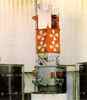
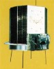
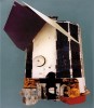
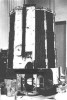
DMSP Block 4/5 satellites
American military earth weather satellite. First Defense Meteorological Satellite Program satellite series.
The first CORONA photos in August 1960 convinced authorities that knowledge of cloud cover over Russia was necessary and could be obtained only via satellite. Since the civilian TIROS program could not yet meet the requirement, the Director, National Reconnaissance Office (DNRO) authorized an interim program.
Launched by "Blue-Scout" boosters, the system would operate for one year until TIROS could take over. Program II began officially on 1 August 1961. Colonel Thomas Haig accepted the program director's position on three conditions: that he could use fixed-price, firm-schedule contracts; that he could select the personnel for his program office; and, that he did not have to use a civilian system engineering and technical direction (SE&TD) contractor. When TIROS delays persisted, Program II continued as Program 35. Confronted by problems of operating the meteorological satellites within the ground system designed for CORONA, Haig proposed two dedicated ground stations and a separate control center operated solely by Air Force personnel-no contractors. Ten months later the nation's first operational satellite program manned entirely by Air Force military personnel became a reality.
After the "Blue Scout" booster proved inadequate, Haig proposed refurbishing Thor intermediate-range ballistic missiles (IRBMs) and adding a second stage plus parts from other boosters to create a new launch vehicle. The latter, dubbed "Burner I," solved the booster problems and simultaneously provided a convenient way to dispose of an embarrassing excess of Thors returned from Europe. No longer an "interim" effort, the military weather satellite received yet another name-Program 417. Its use was expanded to provide information on cloud cover for aircraft flights during the Cuban missile crisis, the evacuation of civilians from the Congo, and air operations in Vietnam.
Haig and his "blue-suit" crew were deeply involved in engineering and development aspects of the program. They designed essential parts for the Burner boosters, invented magnetic spin-rate control of the satellite, conceived and introduced innovations which greatly reduced the cost of ground stations, and developed simplified tracking software. The precedents established and attitudes generated in Haig's program office persisted long after the military meteorological satellite program was declassified and dubbed the Defense Meteorological Satellite Program (DMSP).
Subtopics
 | DMSP Block 4A American earth weather satellite. Defense Meteorological Satellite Program. Meteorology satellite built by RCA Astro for USAF, NRO, USA. Launched 1966 - 1967. |
 | DMSP Block 5A American earth weather satellite. Defense Meteorological Satellite Program. Meteorology satellite built by RCA Astro, USA. Launched 1970 - 1971. |
 | DMSP Block 5B American earth weather satellite. Defense Meteorological Satellite Program. Meteorology satellite built by RCA Astro, USA. Launched 1971 - 1974. |
 | DMSP Block 5C American earth weather satellite. Defense Meteorological Satellite Program. Meteorology satellite built by RCA Astro, USA. Launched 1974 - 1976. |
1965 January 19 - .
05:03 GMT - .
Launch Site: Vandenberg.
Launch Complex: Vandenberg SLC10W.
LV Family: Thor.
Launch Vehicle: Thor MG-18.
- DMSP-Block-4A F1 - .
Payload: DAPP 10 / OPS 7040. Mass: 150 kg (330 lb). Nation: USA.
Agency: USAF.
Program: DMSP.
Class: Earth.
Type: Weather satellite. Spacecraft Bus: DMSP Block 4/5 satellites.
Spacecraft: DMSP Block 4A.
Decay Date: 1979-07-13 . USAF Sat Cat: 973 . COSPAR: 1965-003A. Apogee: 833 km (517 mi). Perigee: 462 km (287 mi). Inclination: 98.8000 deg. Period: 97.60 min.
The first Air Force Thor/Altair (Burner I) space booster was launched from Vandenberg AFB. The Altair upper stage was the fourth stage of the Scout rocket. Defense Meteorological Satellite Program. Launch date was January 18, 1965. The launch was successful and correct orbit was achieved. However, the heat shield on the second stage did not deploy correctly and the mission objectives were not fully realized. This first Burner I bird is distinguishable in photos by its black second stage.
1965 March 18 - .
04:43 GMT - .
Launch Site: Vandenberg.
Launch Complex: Vandenberg SLC10W.
LV Family: Thor.
Launch Vehicle: Thor MG-18.
- DMSP-Block-4A F2 - .
Payload: DAPP 11 / OPS 7353. Mass: 130 kg (280 lb). Nation: USA.
Agency: USAF.
Program: DMSP.
Class: Earth.
Type: Weather satellite. Spacecraft Bus: DMSP Block 4/5 satellites.
Spacecraft: DMSP Block 4A.
Decay Date: 1989-12-31 . USAF Sat Cat: 1273 . COSPAR: 1965-021A. Apogee: 146 km (90 mi). Perigee: 139 km (86 mi). Inclination: 99.0000 deg. Period: 87.30 min. Defense Meteorological Satellite Program. A fully successful launch with all objectives met. The night launch time of 2100 hrs Vandenberg time with a 5 minute launch window was the same for both the first and second Burner I launches..
1965 May 20 - .
16:30 GMT - .
Launch Site: Vandenberg.
Launch Complex: Vandenberg SLC10W.
LV Family: Thor.
Launch Vehicle: Thor Burner 1.
- DMSP-Block-4A F3 - .
Payload: DAPP 12 / OPS 8386. Mass: 130 kg (280 lb). Nation: USA.
Agency: USAF.
Program: DMSP.
Class: Earth.
Type: Weather satellite. Spacecraft Bus: DMSP Block 4/5 satellites.
Spacecraft: DMSP Block 4A.
Decay Date: 2012-03-09 . USAF Sat Cat: 1377 . COSPAR: 1965-038A. Apogee: 731 km (454 mi). Perigee: 503 km (312 mi). Inclination: 98.1000 deg. Period: 97.10 min. Defense Meteorological Satellite Program..
1965 September 10 - .
04:41 GMT - .
Launch Site: Vandenberg.
Launch Complex: Vandenberg SLC10W.
LV Family: Thor.
Launch Vehicle: Thor Burner 1.
- DMSP-Block-4A F4 - .
Payload: DAPP 13 / OPS 8068. Mass: 130 kg (280 lb). Nation: USA.
Agency: USAF.
Program: DMSP.
Class: Earth.
Type: Weather satellite. Spacecraft Bus: DMSP Block 4/5 satellites.
Spacecraft: DMSP Block 4A.
USAF Sat Cat: 1580 . COSPAR: 1965-072A. Apogee: 993 km (617 mi). Perigee: 635 km (394 mi). Inclination: 98.5000 deg. Period: 101.20 min. Defense Meteorological Satellite Program..
1966 January 8 - .
04:48 GMT - .
Launch Site: Vandenberg.
Launch Complex: Vandenberg SLC10W.
LV Family: Thor.
Launch Vehicle: Thor Burner 1.
FAILURE: Second stage failed.. Failed Stage: 2. - DMSP-Block-4A F5 - .
Payload: DAPP 14/OPS 2394. Mass: 130 kg (280 lb). Nation: USA.
Agency: USAF.
Program: DMSP.
Class: Earth.
Type: Weather satellite. Spacecraft Bus: DMSP Block 4/5 satellites.
Spacecraft: DMSP Block 4A.
Decay Date: 1966-01-06 . Defense Meteorological Satellite Program..
1966 March 31 - .
05:41 GMT - .
Launch Site: Vandenberg.
Launch Complex: Vandenberg SLC10W.
LV Family: Thor.
Launch Vehicle: Thor Burner 1.
- DMSP-Block-4A F6 - .
Payload: DAPP 15 / OPS 0340. Mass: 130 kg (280 lb). Nation: USA.
Agency: USAF.
Program: DMSP.
Class: Earth.
Type: Weather satellite. Spacecraft Bus: DMSP Block 4/5 satellites.
Spacecraft: DMSP Block 4A.
USAF Sat Cat: 2125 . COSPAR: 1966-026A. Apogee: 855 km (531 mi). Perigee: 604 km (375 mi). Inclination: 98.3000 deg. Period: 99.40 min. The last Thor/Altair (Burner I) was launched from Vandenberg AFB. The improved Burner II would replace the Altair upper stage. Defense Meteorological Satellite Program..
1966 September 16 - .
04:36 GMT - .
Launch Site: Vandenberg.
Launch Complex: Vandenberg SLC10W.
LV Family: Thor.
Launch Vehicle: Thor Burner 2.
- DMSP-Block-4A F7 - .
Payload: DAPP 1416 (FTV-3) / OPS 6026. Mass: 125 kg (275 lb). Nation: USA.
Agency: USAF.
Program: DMSP.
Class: Earth.
Type: Weather satellite. Spacecraft Bus: DMSP Block 4/5 satellites.
Spacecraft: DMSP Block 4A.
USAF Sat Cat: 2418 . COSPAR: 1966-082A. Apogee: 857 km (532 mi). Perigee: 674 km (418 mi). Inclination: 98.3000 deg. Period: 100.20 min. Defense Meteorological Satellite Program..
1967 February 8 - .
08:00 GMT - .
Launch Site: Vandenberg.
Launch Complex: Vandenberg SLC10W.
LV Family: Thor.
Launch Vehicle: Thor Burner 2.
- DMSP-Block-4A F8 - .
Payload: DAPP 2418 (FTV-2) / OPS 6073. Mass: 130 kg (280 lb). Nation: USA.
Agency: USAF.
Program: DMSP.
Class: Earth.
Type: Weather satellite. Spacecraft Bus: DMSP Block 4/5 satellites.
Spacecraft: DMSP Block 4A.
USAF Sat Cat: 2669 . COSPAR: 1967-010A. Apogee: 846 km (525 mi). Perigee: 771 km (479 mi). Inclination: 99.1000 deg. Period: 101.10 min. Defense Meteorological Satellite Program; lower than planned orbit, but still operational..
1967 August 23 - .
04:41 GMT - .
Launch Site: Vandenberg.
Launch Complex: Vandenberg SLC10W.
LV Family: Thor.
Launch Vehicle: Thor Burner 2.
- DMSP-Block-4A F9 - .
Payload: DAPP 3419 (FTV-4) / OPS 7202. Mass: 130 kg (280 lb). Nation: USA.
Agency: USAF.
Program: DMSP.
Class: Earth.
Type: Weather satellite. Spacecraft Bus: DMSP Block 4/5 satellites.
Spacecraft: DMSP Block 4A.
USAF Sat Cat: 2920 . COSPAR: 1967-080A. Apogee: 873 km (542 mi). Perigee: 818 km (508 mi). Inclination: 98.9000 deg. Period: 101.90 min. Defense Meteorological Satellite Program..
1967 October 11 - .
07:57 GMT - .
Launch Site: Vandenberg.
Launch Complex: Vandenberg SLC10W.
LV Family: Thor.
Launch Vehicle: Thor Burner 2.
- DMSP-Block-4A F10 - .
Payload: DAPP 4417 (FTV-5) / OPS 1264. Mass: 130 kg (280 lb). Nation: USA.
Agency: USAF.
Program: DMSP.
Class: Earth.
Type: Weather satellite. Spacecraft Bus: DMSP Block 4/5 satellites.
Spacecraft: DMSP Block 4A.
USAF Sat Cat: 2980 . COSPAR: 1967-096A. Apogee: 796 km (494 mi). Perigee: 638 km (396 mi). Inclination: 99.2000 deg. Period: 99.10 min. Defense Meteorological Satellite Program..
1968 May 23 - .
04:38 GMT - .
Launch Site: Vandenberg.
Launch Complex: Vandenberg SLC10W.
LV Family: Thor.
Launch Vehicle: Thor Burner 2.
- DMSP-Block-4A F11 - .
Payload: DAPP 4B F-1 (FTV-8) / OPS 7869. Mass: 130 kg (280 lb). Nation: USA.
Agency: USAF.
Program: DMSP.
Class: Earth.
Type: Weather satellite. Spacecraft Bus: DMSP Block 4/5 satellites.
Spacecraft: DMSP Block 4A.
USAF Sat Cat: 3266 . COSPAR: 1968-042A. Apogee: 883 km (548 mi). Perigee: 806 km (500 mi). Inclination: 98.9000 deg. Period: 101.80 min. Defense Meteorological Satellite Program..
1968 October 23 - .
04:34 GMT - .
Launch Site: Vandenberg.
Launch Complex: Vandenberg SLC10W.
LV Family: Thor.
Launch Vehicle: Thor Burner 2.
- DMSP-Block-4A F12 - .
Payload: DAPP 6422 (FTV-7) / OPS 4078. Mass: 130 kg (280 lb). Nation: USA.
Agency: USAF.
Program: DMSP.
Class: Earth.
Type: Weather satellite. Spacecraft Bus: DMSP Block 4/5 satellites.
Spacecraft: DMSP Block 4A.
USAF Sat Cat: 3510 . COSPAR: 1968-092A. Apogee: 828 km (514 mi). Perigee: 783 km (486 mi). Inclination: 98.7000 deg. Period: 101.00 min. Defense Meteorological Satellite Program..
1969 July 23 - .
04:39 GMT - .
Launch Site: Vandenberg.
Launch Complex: Vandenberg SLC10W.
LV Family: Thor.
Launch Vehicle: Thor Burner 2.
- DMSP-Block-4A F13 - .
Payload: DAPP 7421 (FTV-6) / OPS 1127. Mass: 130 kg (280 lb). Nation: USA.
Agency: USAF.
Program: DMSP.
Class: Earth.
Type: Weather satellite. Spacecraft Bus: DMSP Block 4/5 satellites.
Spacecraft: DMSP Block 4A.
USAF Sat Cat: 4047 . COSPAR: 1969-062A. Apogee: 835 km (518 mi). Perigee: 768 km (477 mi). Inclination: 98.8000 deg. Period: 100.90 min. Defense Meteorological Satellite Program..
1970 February 11 - .
08:40 GMT - .
Launch Site: Vandenberg.
Launch Complex: Vandenberg SLC10W.
LV Family: Thor.
Launch Vehicle: Thor Burner 2.
- DMSP-Block-5A F1 - .
Payload: DAPP 1524 / OPS 0054. Mass: 195 kg (429 lb). Nation: USA.
Agency: USAF.
Program: DMSP.
Class: Earth.
Type: Weather satellite. Spacecraft Bus: DMSP Block 4/5 satellites.
Spacecraft: DMSP Block 5A.
USAF Sat Cat: 4331 . COSPAR: 1970-012A. Apogee: 840 km (520 mi). Perigee: 749 km (465 mi). Inclination: 98.8000 deg. Period: 100.80 min. Defense Meteorological Satellite Program..
1970 September 3 - .
08:39 GMT - .
Launch Site: Vandenberg.
Launch Complex: Vandenberg SLC10W.
LV Family: Thor.
Launch Vehicle: Thor Burner 2.
- DMSP-Block-5A F2 - .
Payload: DAPP 2525 / OPS 0203. Mass: 195 kg (429 lb). Nation: USA.
Agency: USAF.
Program: DMSP.
Class: Earth.
Type: Weather satellite. Spacecraft Bus: DMSP Block 4/5 satellites.
Spacecraft: DMSP Block 5A.
USAF Sat Cat: 4512 . COSPAR: 1970-070A. Apogee: 837 km (520 mi). Perigee: 739 km (459 mi). Inclination: 99.0000 deg. Period: 100.60 min. Defense Meteorological Satellite Program..
1971 February 17 - .
03:52 GMT - .
Launch Site: Vandenberg.
Launch Complex: Vandenberg SLC10W.
LV Family: Thor.
Launch Vehicle: Thor Burner 2.
- DMSP-Block-5A F3 - .
Payload: DAPP 3526 / OPS 5268. Mass: 195 kg (429 lb). Nation: USA.
Agency: USAF.
Program: DMSP.
Class: Earth.
Type: Weather satellite. Spacecraft Bus: DMSP Block 4/5 satellites.
Spacecraft: DMSP Block 5A.
USAF Sat Cat: 4953 . COSPAR: 1971-012A. Apogee: 799 km (496 mi). Perigee: 741 km (460 mi). Inclination: 98.7000 deg. Period: 100.20 min. Defense Meteorological Satellite Program..
1971 October 14 - .
07:51 GMT - .
Launch Site: Vandenberg.
Launch Complex: Vandenberg SLC10W.
LV Family: Thor.
Launch Vehicle: Thor Burner 2A.
- DMSP-Block-5B F1 - .
Payload: DMSP 4527 / OPS 4311. Mass: 195 kg (429 lb). Nation: USA.
Agency: USAF.
Program: DMSP.
Class: Earth.
Type: Weather satellite. Spacecraft Bus: DMSP Block 4/5 satellites.
Spacecraft: DMSP Block 5B.
USAF Sat Cat: 5557 . COSPAR: 1971-087A. Apogee: 850 km (520 mi). Perigee: 772 km (479 mi). Inclination: 99.1000 deg. Period: 101.10 min. Defense Meteorological Satellite Program..
1972 March 24 - .
08:46 GMT - .
Launch Site: Vandenberg.
Launch Complex: Vandenberg SLC10W.
LV Family: Thor.
Launch Vehicle: Thor Burner 2A.
- DMSP-Block-5B F2 - .
Payload: DMSP 5528 / OPS 5058. Mass: 195 kg (429 lb). Nation: USA.
Agency: USAF.
Program: DMSP.
Class: Earth.
Type: Weather satellite. Spacecraft Bus: DMSP Block 4/5 satellites.
Spacecraft: DMSP Block 5B.
USAF Sat Cat: 5903 . COSPAR: 1972-018A. Apogee: 858 km (533 mi). Perigee: 781 km (485 mi). Inclination: 98.9000 deg. Period: 101.30 min. Defense Meteorological Satellite Program..
1972 November 9 - .
03:23 GMT - .
Launch Site: Vandenberg.
Launch Complex: Vandenberg SLC10W.
LV Family: Thor.
Launch Vehicle: Thor Burner 2A.
- DMSP-Block-5B F3 - .
Payload: DMSP 6530 / OPS 7323. Mass: 195 kg (429 lb). Nation: USA.
Agency: USAF.
Program: DMSP.
Class: Earth.
Type: Weather satellite. Spacecraft Bus: DMSP Block 4/5 satellites.
Spacecraft: DMSP Block 5B.
USAF Sat Cat: 6275 . COSPAR: 1972-089A. Apogee: 841 km (522 mi). Perigee: 785 km (487 mi). Inclination: 98.6000 deg. Period: 101.10 min.
A Thor/Delta booster launched from Cape Canaveral successfully placed a Canadian communications satellite, ANIK I, into orbit. This was the 75th Thor/Delta to be launched from the Cape and the first Long Tank Thrust Augmented Thor/Delta to be launched from the Cape with nine strap-on solid rocket motors. It placed the Telestar-A (ANIK) communications satellite in orbit for Canada. Defense Meteorological Satellite Program.
1973 August 17 - .
04:49 GMT - .
Launch Site: Vandenberg.
Launch Complex: Vandenberg SLC10W.
LV Family: Thor.
Launch Vehicle: Thor Burner 2A.
- DMSP-Block-5B F4 - .
Payload: DMSP 7529 / OPS 8364. Mass: 195 kg (429 lb). Nation: USA.
Agency: USAF.
Program: DMSP.
Class: Earth.
Type: Weather satellite. Spacecraft Bus: DMSP Block 4/5 satellites.
Spacecraft: DMSP Block 5B.
USAF Sat Cat: 6787 . COSPAR: 1973-054A. Apogee: 819 km (508 mi). Perigee: 779 km (484 mi). Inclination: 98.9000 deg. Period: 100.90 min. Defense Meteorological Satellite Program..
1974 March 16 - .
08:00 GMT - .
Launch Site: Vandenberg.
Launch Complex: Vandenberg SLC10W.
LV Family: Thor.
Launch Vehicle: Thor Burner 2A.
- DMSP-Block-5B F5 - .
Payload: DMSP 8531 / OPS 8579. Mass: 195 kg (429 lb). Nation: USA.
Agency: USAF.
Program: DMSP.
Class: Earth.
Type: Weather satellite. Spacecraft Bus: DMSP Block 4/5 satellites.
Spacecraft: DMSP Block 5B.
USAF Sat Cat: 7218 . COSPAR: 1974-015A. Apogee: 846 km (525 mi). Perigee: 757 km (470 mi). Inclination: 99.1000 deg. Period: 100.90 min. Defense Meteorological Satellite Program..
1974 August 9 - .
03:22 GMT - .
Launch Site: Vandenberg.
Launch Complex: Vandenberg SLC10W.
LV Family: Thor.
Launch Vehicle: Thor Burner 2A.
- DMSP-Block-5C F1 - .
Payload: DMSP 9532 / OPS 6983. Mass: 195 kg (429 lb). Nation: USA.
Agency: USAF.
Program: DMSP.
Class: Earth.
Type: Weather satellite. Spacecraft Bus: DMSP Block 4/5 satellites.
Spacecraft: DMSP Block 5C.
USAF Sat Cat: 7411 . COSPAR: 1974-063A. Apogee: 844 km (524 mi). Perigee: 779 km (484 mi). Inclination: 98.8000 deg. Period: 101.10 min. Defense Meteorological Satellite Program..
1975 May 24 - .
03:22 GMT - .
Launch Site: Vandenberg.
Launch Complex: Vandenberg SLC10W.
LV Family: Thor.
Launch Vehicle: Thor Burner 2A.
- DMSP-Block-5C F2 - .
Payload: DMSP 10533 / OPS 6226. Mass: 194 kg (427 lb). Nation: USA.
Agency: USAF.
Program: DMSP.
Class: Earth.
Type: Weather satellite. Spacecraft Bus: DMSP Block 4/5 satellites.
Spacecraft: DMSP Block 5C.
USAF Sat Cat: 7816 . COSPAR: 1975-043A. Apogee: 880 km (540 mi). Perigee: 794 km (493 mi). Inclination: 98.7000 deg. Period: 101.70 min. Defense Meteorological Satellite Program..
1976 February 19 - .
07:52 GMT - .
Launch Site: Vandenberg.
Launch Complex: Vandenberg SLC10W.
LV Family: Thor.
Launch Vehicle: Thor Burner 2A.
FAILURE: Early booster cut-off due to incorrect calculation of the Thor fuel load.. Failed Stage: G. - DMSP-Block-5C F3 - .
Payload: DMSP 11534/Star 26B S/N 009 / OPS 5140. Mass: 175 kg (385 lb). Nation: USA.
Agency: USAF.
Program: DMSP.
Class: Earth.
Type: Weather satellite. Spacecraft Bus: DMSP Block 4/5 satellites.
Spacecraft: DMSP Block 5C.
Decay Date: 1976-02-19 . USAF Sat Cat: 8696 . COSPAR: 1976-016A. Apogee: 361 km (224 mi). Perigee: 89 km (55 mi). Inclination: 98.9000 deg. Period: 88.90 min. Defense Meteorological Satellite Program; unusable orbit. Last of the Thor Burner missions..
1976 May 22 - .
1976 December 9 - .
1977 Feb - .
- A tracking system was installed at Hickam AFB, Hawaii, that allowed Hickam to track DMSP satellites and receive data directly from them. - .
Spacecraft Bus: DMSP Block 4/5 satellites.
Spacecraft: DMSP Block 5C.
The system was declared operational in June, and Hickam began functioning as a weather readout station in the DMSP system..
1977 December 1 - .
- The Air Weather Service decided that it no longer required support from DMSP Block 5C satellites, and the two remaining Block 5C satellites were turned off permanently. This ended the Block 5C era. - .
Spacecraft Bus: DMSP Block 4/5 satellites.
Spacecraft: DMSP Block 5C.
Home - Search - Browse - Alphabetic Index: 0- 1- 2- 3- 4- 5- 6- 7- 8- 9
A- B- C- D- E- F- G- H- I- J- K- L- M- N- O- P- Q- R- S- T- U- V- W- X- Y- Z
© 1997-2017 Mark Wade - Contact
© / Conditions for Use
|