
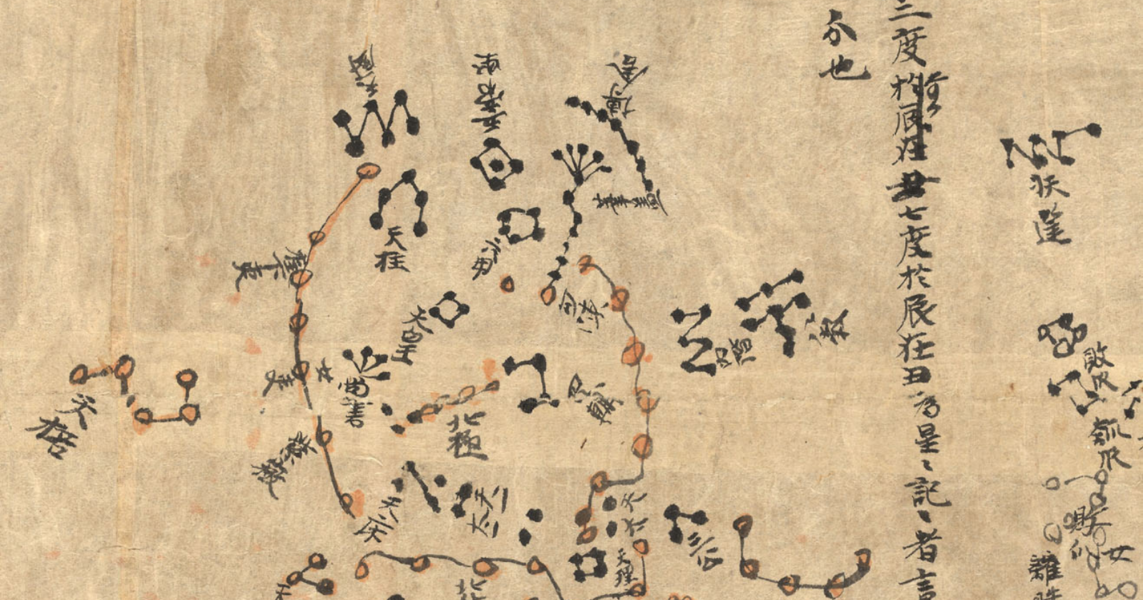
On the edge of the Gobi Desert, near the oasis town of Dunhuang in western China, hundreds of Buddhist cave temples are carved into a long cliff face. In 1900, a man named Wang Yuanlu, who had appointed himself caretaker of the caves, was clearing sand from one of them when he noticed something odd about a wall.
Behind it was a hidden chamber, packed from floor to ceiling with bundles of scrolls. Among them, unnoticed for years, was a long roll of paper covered in dots, lines and Chinese characters. It was a map of the entire night sky.
The cave that time forgot
The Mogao Caves were carved and painted over roughly a thousand years, starting in the 4th century. Dunhuang sat on the Silk Road, the network of trade routes linking China with Central Asia and beyond, and the caves became a center of Buddhist worship and learning.
At some point around the early 11th century, someone sealed a small side chamber, now known as the Library Cave, with its contents inside. Nobody knows exactly why. The dry desert air preserved what was inside remarkably well.
When Wang Yuanlu found it, the cave held around 40,000 manuscripts, paintings and printed documents, mostly Buddhist texts. It also contained the Diamond Sutra, printed in 868, which is the world’s earliest dated complete printed book.
Carried off to London
News of the find spread slowly. In 1907, the Hungarian-born British archaeologist Aurel Stein arrived at Dunhuang and persuaded Wang to let him take thousands of manuscripts in exchange for a donation. Explorers from France, Russia, Japan and elsewhere soon followed.
Today, the Dunhuang manuscripts are scattered across collections around the world, a source of lasting controversy in China. The star chart ended up in the British Museum and is now held by the British Library in London, catalogued as Or.8210/S.3326.
A map of the whole sky
For about a century, the chart was mainly used as an illustration in books. Then, in 2009, a team led by French astrophysicist Jean-Marc Bonnet-Bidaud, working with Françoise Praderie of the Paris Observatory and Susan Whitfield of the British Library, published the first full scientific study of it.
They found that the atlas shows 1,339 stars grouped into 257 Chinese constellations, covering the whole sky visible from the Northern Hemisphere. It’s drawn in ink on thin paper, with stars in different colors that reflect three ancient Chinese star catalogs.
The atlas is made up of 12 maps, each covering a strip of sky about 30 degrees wide along the celestial equator, plus a separate map of the region around the North Pole. On that polar map, the Big Dipper is easy to spot.
Surprisingly accurate
The researchers compared the chart’s star positions with modern measurements. For the brightest stars, the positions were accurate to within about 1.5 to 4 degrees, which is impressive for a hand-drawn chart.
The way the maps were drawn was also sophisticated. The 12 equatorial maps use a projection similar to a cylindrical projection, while the polar map uses a different projection centered on the pole. The team concluded that precise mathematical methods were used, centuries before similar techniques became common in European mapmaking.
Dating the atlas
The chart isn’t signed or dated, so the researchers had to work out its age from clues in the text. One key clue was how certain characters were written. In imperial China, writers often avoided or altered characters that appeared in the reigning emperor’s personal name.
Based on these taboo characters and other evidence, the team dated the atlas to between about 649 and 684, during the early Tang dynasty. That’s about 1,350 years ago, earlier than a previous estimate of around the year 940. Guinness World Records lists it as the oldest surviving star chart on manuscript.
The researchers suggested it may be connected to Li Chunfeng, a famous Tang dynasty astronomer and mathematician, though that remains uncertain.
Older maps, but none this complete
Other cultures recorded the stars long before the Tang dynasty. The Babylonians, Egyptians and Greeks all cataloged stars and constellations, and some older star diagrams survive in fragments or carvings.
What makes the Dunhuang atlas special is its completeness. As far as researchers know, no older complete star atlas survives from any civilization. It’s also the earliest known picture of almost all the traditional Chinese constellations.
More than 1,300 years after it was drawn, and more than 900 years after it was sealed in a cave, it still shows the night sky much as it looks today.